Bentley Systems Announces Seequent’s Acquisition of Aarhus GeoSoftware
8th July 2021
Bentley Systems Announces Seequent’s Acquisition of Aarhus GeoSoftware8th July 2021
Bentley Systems Announces Seequent’s Acquisition of Aarhus GeoSoftware1st July 2021
Ekinops and IEC Telecom Group deliver compact portable satellite communication solution14th June 2021
Delaware partners with VertiGIS to expand Geospatial Asset Management capabilities6th May 2021
Latest Topcon construction and survey software available now for compatible, comprehensive connectivity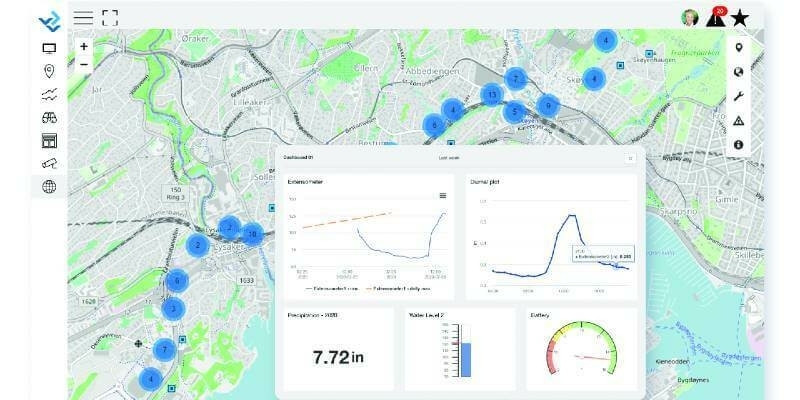
5th May 2021
Bentley Systems Announces Acquisitions of sensemetrics and Vista Data Vision, Leaders Respectively in Software for Infrastructure Instrumentation and Sensor Management19th April 2021
Processing of Quantum-Systems Drone Data Integrated in SimActive Software15th April 2021
Bentley Systems Announces Acquisition of Mobility Simulation Leader INRO
17th March 2021
Contractor invests in the Verity enterprise software solution for construction verification
16th March 2021
1Spatial announce the release of 1DataGateway 2.3.0
14th March 2021
1Spatial announce the release of 1Integrate 2.8.1
12th March 2021
The FME World Fair is Coming to a Screen Near You
2nd March 2021
SimActive Software Integrated in LiDAR Solution for Drones
2nd March 2021
Leica Geosystems introduces one app for all terrestrial laser scanning portfolio
2nd March 2021
1Spatial Awarded Safe Software’s Partner Award of Excellence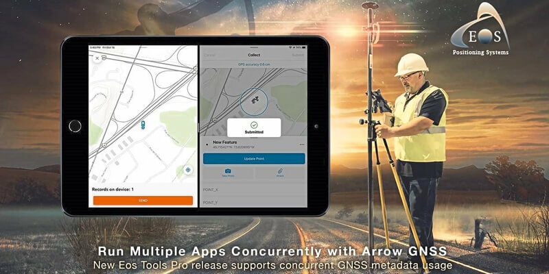
2nd March 2021
Eos Positioning Systems announces ability to consume Arrow GNSS location data in multiple Esri apps concurrently
2nd March 2021
Parrot, UgCS partnership augments drone mission planning, mapping4th February 2021
New Workability Options Enhance Carlson iCAD 202119th January 2021
Trimble Business Center Streamlines Point Cloud Workflows and Adds Vertical Applications Enabling Survey and Mapping Professionals to Maximize Productivity
18th January 2021
Real estate management during the COVID pandemic - Webinar14th January 2021
Virtual Surveyor Introduces Curb & Gutter Mapping in New Version of Drone Surveying Software14th January 2021
SBG Systems to release the virtual base station feature in Qinertia, its in-house post-processing software11th January 2021
Student's Space Archaeology start-up showcased at world’s biggest tech show17th December 2020
Garmin announces exciting updates to the GTN Xi Series of navigators10th December 2020
Parrot, UgCS partnership augments drone mission planning, mapping
3rd December 2020
Garmin Announces G1000 Nxi Integration With Blackhawk Engine+ Upgrade For King Air 300 And King Air 350
17th November 2020
Vega Launches the Taranis Satellite to Explore Thunderstorm Lights: Double Reference for SPACEBEL1st November 2020
GeoMax launches major update to X-PAD software
29th October 2020
Simplifying location data access and processing29th October 2020
Hexagon Unveils HxGN Smart Census 2020 for Enhanced Citizen Data Collection29th October 2020
Teledyne DALSA releases powerful suite of image processing and artificial intelligence software24th September 2020
Fragmentation analysis leads updates in Maptek PointStudio 2020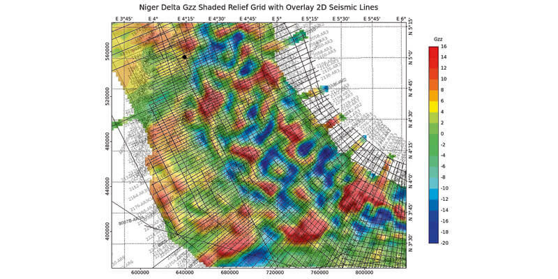
17th September 2020
CGG Multi-Physics Updates LCT Software with Innovations for Imaging Potential Field Data
16th September 2020
Garmin Autoland Achieves EASA And FAA Certification On Daher TBM 94010th September 2020
Esri Acquires nFrames to Enhance Its 3D Capabilities9th September 2020
digitalPMRExpo 2020: Europe’s Leading Trade Fair for Secure Communications Goes Digital7th September 2020
GSSI Updates to StructureScan Mini XT GPR Kit and Palm XT Antenna
28th August 2020
1Spatial to host online events focusing on supply chain innovation and collaboration
26th August 2020
Garmin Receives Approval For New G5000 Features And Upgrades For The Citation Excel And Citation XLS19th August 2020
Garmin Announces Certification Of The G1000 Nxi Upgrade In The Piper Meridian18th August 2020
Streetdrone Secures Uk Government Funding For 5g Autonomous Truck Project11th August 2020
Recursos Técnicos Madrid, S.L. And Aec Solutions Engineers S.A.C. have signed a Collaboration Agreement4th August 2020
Garmin Autoland Achieves Easa And Faa Certification On Daher Tbm 940
3rd August 2020
1Spatial releases new webinars and training courses
3rd August 2020
Cadcorp SIS 9 service release enables direct link to Ordnance Survey Data Hub31st July 2020
Topcon’s MAGNET Drives Forward Norway’s Most Spectacular Construction Project - Connecting Five Islands29th July 2020
New Topcon laser with mobile app display connectivity to bring improved productivity to today’s job sites