
HERE appoints Peter Kürpick as Chief Platform Officer
16th August 2016
HERE appoints Peter Kürpick as Chief Platform Officer16th August 2016
HERE appoints Peter Kürpick as Chief Platform Officer13th August 2016
GGP Systems partners with Blackpool Council13th August 2016
East View Signs Historic POD Contract with SEMAR12th August 2016
European Space Imaging announces new partnership with Vricon12th August 2016
Global Mapper Chosen for Coastal Mapping Project12th August 2016
PCI Geomatics Releases Geomatica 2016 Service Pack 1
12th August 2016
Bristow & Sutor Installs GreenRoad Solution12th August 2016
GIS Technology Proves Fundamental in Battle against Zika Virus11th August 2016
Impressive Speaker Line-Up for Luciad INTERACT

10th August 2016
Barrow Upon Soar Rail Closure Prompts Monitoring Calls10th August 2016
MICROMINE's latest feature on Implicit Modelling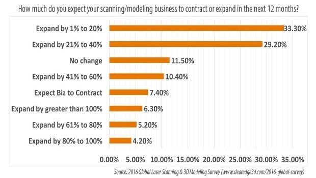
9th August 2016
78.7% of AEC Firms Expect Scanning/Modeling Work to Increase9th August 2016
OGC adopts SensorThings API Part 1: Sensing Standard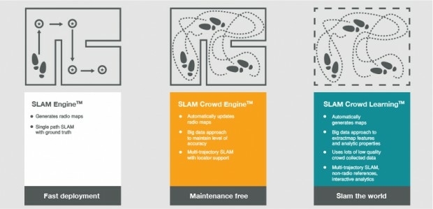
9th August 2016
indoo.rs revolutionizing the Indoor Positioning industry

6th August 2016
Abu Dhabi to host industry giants at NATRANS Expo
6th August 2016
Point Greys New Spinnaker SDK Leverages GenICam3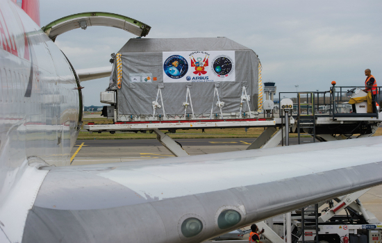
6th August 2016
PerúSAT-1 satellite is now on its way to Kourou launch site
6th August 2016
New Blackfly S - the Latest Imaging Technology in Compact Housing
5th August 2016
6th International Conference on Cartography and GIS
5th August 2016
160 Commercial Drone Companies Showcase UAV Technology at InterDrone
5th August 2016
Geospatial Minds for Society – GI_Forum 2016 in Retrospect5th August 2016
Cityworks Announces the Release of Cityworks 15.15th August 2016
OGC requests participation in its Citizen Science DWG5th August 2016
Eternix Ltd. announces the release of Blaze Terra 5.04th August 2016
OGC requests participation in its Marine DWG
4th August 2016
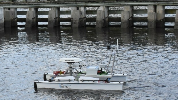
SeaRobotics Delivers Unmanned Surface Vehicle2nd August 2016
Orbit GT and Soluciones Geoinformaticas, sign Reseller Agreement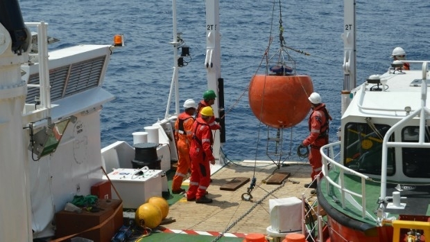
2nd August 2016
Fugro Completes Ghana Metocean Data Acquisition For Hess Corporation2nd August 2016
New senseFly financing and insurance packages for Drone operators2nd August 2016
HERE appoints Kelley Steven-Waiss as Chief Human Resources Officer
2nd August 2016
The integrated management of municipal infrastructure2nd August 2016
AirGon LLC Revolutionizes Drone Data Extraction2nd August 2016
Geneq's announcement of iSXBlue receivers compatibility2nd August 2016
Esri and Leica Partner to Offer Grants to Governments2nd August 2016
Pix4D Elevates Agriculture Software to Desktop & Cloud Solution
1st August 2016
The Truth About Drones in Mapping and Surveying29th July 2016
Key Developments to Luciad's Geospatial Software Solutions