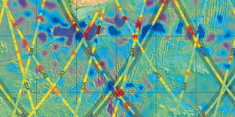
The Copernicus Sentinel-6 Michael Freilich satellite delivers promising first altimeter data
2nd March 2021
The Copernicus Sentinel-6 Michael Freilich satellite delivers promising first altimeter data
2nd March 2021
The Copernicus Sentinel-6 Michael Freilich satellite delivers promising first altimeter data24th February 2021
Satellites to help safeguard sustainability of palm oil, with launch of UK and Mexico project18th February 2021
The Italian company e-GEOS and the Argentinian company VENG have signed a strategic agreement for the world-wide distribution of satellite data from the SAOCOM constellation15th February 2021
First Airbus Eurostar Neo satellite is born15th February 2021
Biomass forest sensing satellite shaping up
9th February 2021
Slovenia Releases Color Image from NEMO-HD Microsatellite Built by Space Flight Laboratory (SFL) in Collaboration with SPACE-SI
5th February 2021
Astroscale U.S. Appoints Sandor Nemethy as Director, GEO Spacecraft Systems

2nd February 2021
Ghana launches National Map of Forests and Land Use28th January 2021
SimActive Used to Determine Solar Potential from Satellite Imagery22nd January 2021
CGG Joins Mine Tailings Monitoring Research Project Led by Amira17th January 2021
CGG Satellite Mapping Completes Barents Sea Seeps Study for Norwegian Petroleum Directorate14th January 2021
GAF AG and BKG intensify their cooperation regarding the provision of multi-source remote sensing data14th January 2021
Terra Cover Launches ReaLSAT as New Surface Water Monitoring Service14th January 2021
East View Geospatial Partners with Capella Space as Early Reseller in North America14th January 2021
Swedish Space Corporation to launch satellites from Esrange Space Center11th January 2021
Airbus signs multi-satellite contract with Intelsat for OneSat flexible satellites7th January 2021
Telespazio and e-GEOS, in collaboration with National Geographic Italia, present the Love Planet Earth 2021 Calendar7th January 2021
Altius: a New Satellite « Made in Belgium » with SPACEBEL Software6th January 2021
Astroscale Ships ELSA-d Spacecraft to Launch Site6th January 2021
Airbus-built CSO-2 French military Earth observation satellite launched successfully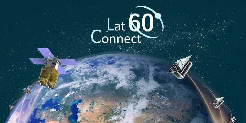
4th January 2021
UP42 to Offer Smart Satellite Data from Australia’s LatConnect 60 on the UP42 Geospatial Marketplace14th December 2020
4EI Announces New UAE Managing Director, Allyson Jenkins10th December 2020
RS Fire 2020: RECORDINGS NOW AVAILABLE FROM THE REMOTE SENSING & WILDLAND FIRE SYMPOSIUM SERIES!10th December 2020
Recycle2Trade to develop new landfill methane emission monitoring intelligence platform6th December 2020
Airbus to deliver radar instrument for new Copernicus ROSE-L mission4th December 2020
Launch success for UAE’s FalconEye satellite1st December 2020
UP42 Hosts Webinar on Fusion of Satellite Imagery, AIS Data, Machine Learning for Maritime Surveillance22nd November 2020
Seeing the seas – “Sentinel-6 Michael Freilich” satellite successfully lifted off into space17th November 2020
Space Flight Laboratory (SFL) Awarded Contract by GHGSat Inc. to Build Three More Greenhouse Gas Monitoring Microsatellites16th November 2020
Airbus wins ESA’s LSTM temperature-check mission for Copernicus next generation12th November 2020
GAF AG and BKG intensify their cooperation regarding the provision of multi-source remote sensing data
6th November 2020
Deepest Gratitude and Appreciation for the Invaluable Support Provided for the 10th IGRSM International Conference and Exhibition on Geospatial & Remote Sensing (IGRSM 2020)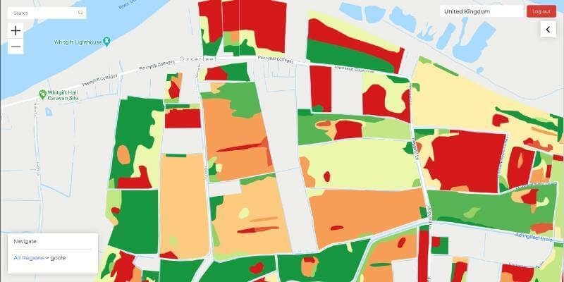
5th November 2020
Mantle Labs to develop new soil moisture-based drought insurance solution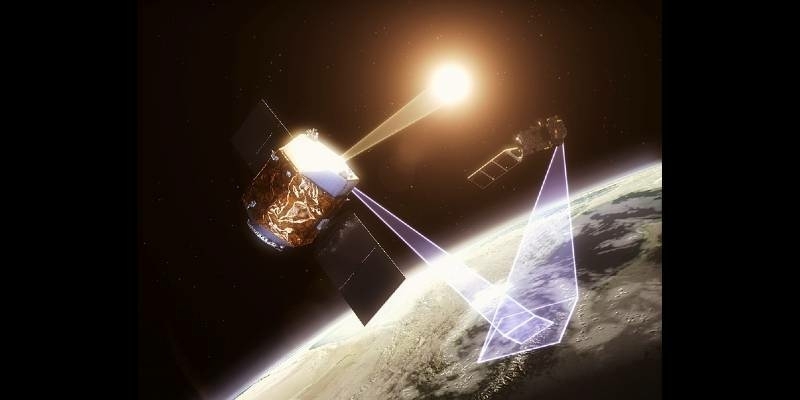
4th November 2020
Airbus wins European Space Agency TRUTHS mission study for metrological traceability of Earth observation data
1st November 2020
Just 2 Weeks to Go Until SMi Group’s 22nd Annual Global MilSatCom Virtual Conference & Exhibition29th October 2020
British Sugar adopts Rezatec’s Innovative Satellite Analytics to Optimise the Supply of Sugar Beet29th October 2020
Satellite Imagery Specialist 4 Earth Intelligence Appoints Managing Director29th October 2020
SkyWatch and Picterra Join Forces to Make Geospatial Insights Available to All29th October 2020
AiDash Taps UP42 Earth Observation Platform to Create Vegetation Management System for Electric Utilities29th October 2020
COVID-19: e-GEOS (Telespazio/ASI) will develop a solution to monitor the economic recovery29th October 2020
Space Flight Laboratory Announces Launch of Atmospheric Monitoring and Earth Observation Microsatellites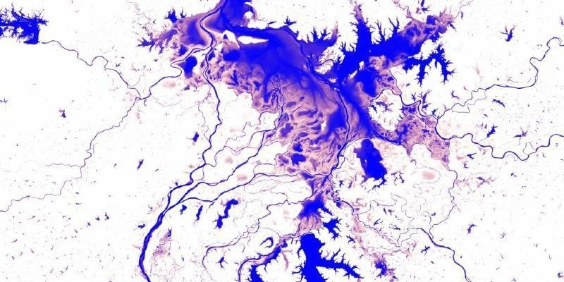
26th October 2020
First-of-its-kind surface water Atlas brings together 35 years of satellite data22nd October 2020
RS Fire 2020: The Remote Sensing & Wildland Fire Symposium Series13th October 2020
Media Briefing on Next-generation Ocean-monitoring Satellite Mission