Emoji map by Europa Technologies wins Most Unique award at Esri UC
19th July 2017
Emoji map by Europa Technologies wins Most Unique award at Esri UC19th July 2017
Emoji map by Europa Technologies wins Most Unique award at Esri UC14th July 2017
U.S. Army Corps Adds Global Mapper to its List of Approved Software13th July 2017
Managing Assets from Different Angles- SuperGIS 3D Earth Server13th July 2017
SuperSurv 10 Wins Golden Map Award Issued by TGIS
13th July 2017
User-defined Coordinate System Will Soon Be Available in SuperSurv 10
13th July 2017
SuperSurv 10 Selected for Coastal Protection in Thailand13th July 2017
Esri and NXN Partner to Create Smart Cities Internationally
13th July 2017
Bluesky Launches Nationwide Map of Building Heights.jpg)
12th July 2017
Learn More About Maptitude at the NCSL Annual Conference12th July 2017
The Science of Where Forward Recognized at Esri Awards12th July 2017
TerraGo Software Utilized for Official Guide to Hong Kong12th July 2017
Esri and Microsoft Join Forces to Accelerate Conservation
12th July 2017
8th BaSYS User Conference with record number of participants11th July 2017
Esri Expands Its World Geocoding Service Capability11th July 2017
ArcGIS 10.5 Enterprise Architecture Powers DigitalGlobe's Offerings11th July 2017
UrtheCast and Esri partner in bringing imagery to life in ArcGIS11th July 2017
Remote Geo LineVision available in the Esri Marketplace11th July 2017
Esri Adds Airbus Global Elevation Data to Online Maps10th July 2017
ArcGIS Hub Gives Communities a Powerful Location-Based Solution10th July 2017
Esri Honored by San Diego with "Esri User Conference Day" Proclamation10th July 2017
PCI Geomatics to Present Historical Airphoto Processing Case Study10th July 2017
Esri and HERE sign multi-year map data licensing agreement10th July 2017
Schneider Electric to Showcase at 2017 Esri User Conference
10th July 2017
OS releases open dataset and free map of Britain’s Greenspaces10th July 2017
Europa Technologies: finalist in prestigious insurance industry awards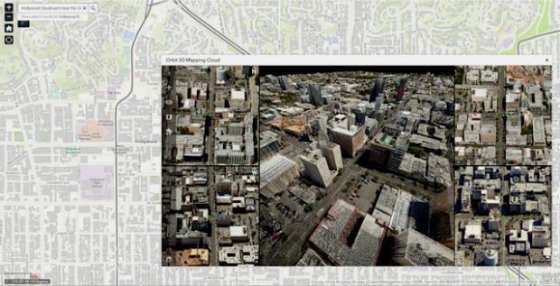
7th July 2017
Orbit GT and Vexcel Imaging showcase Oblique and Streetlevel 3D data
7th July 2017
Carbomap Ready to Map the World with Advanced LiDAR on Fixed-Wing UAV6th July 2017
DAT/EM Systems International Updates Landscape Software
6th July 2017
Esri's Online Learning Guide for Working with Imagery and ArcGIS6th July 2017
Disy and Talend Introduce New Connector for Geospatial Integration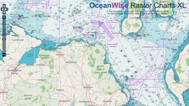
6th July 2017
Marine Mapping Agreement for Northern Ireland6th July 2017
Proceedings of the GSDI 15 World Conference Published6th July 2017
URISA Activities During the Esri User Conference
6th July 2017
Esri CityEngine 2017 Makes Urban Planning More Efficient
5th July 2017
NEW Architectural 3D Models of UK available from Joanna-James5th July 2017
OGC announces Geoscience Australia as its newest Principal Member
5th July 2017
Understanding large-scale plant health with Satellite Data3rd July 2017
Winners of Asian Utility Innovator’s Awards 2017 Announced
1st July 2017
2017 GIS in Transit Conference Approved for Nearly 50 AICP-CM Credits
30th June 2017
Commonplace and Waltham Forest win best stakeholder engagement Award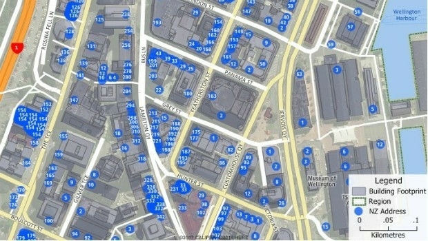
30th June 2017
Maptitude Now Has 2 Million New Zealand Address Points
29th June 2017
Dairy farmers to benefit from satellite data29th June 2017
CompassDrone™ to Demo Integration of DJI Video with ArcGIS