
Bluesky's Tree Map Helps Community Forest Rebuild Environment
25th October 2017
Bluesky's Tree Map Helps Community Forest Rebuild Environment
25th October 2017
Bluesky's Tree Map Helps Community Forest Rebuild Environment24th October 2017
VSTEP provide CAE with bridge simulators for UAE Naval Training Centre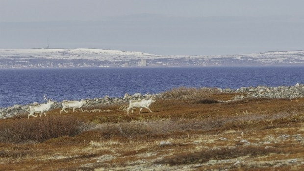
24th October 2017
Globalstar IoT Solution Protects Norway Reindeer from Train Collisions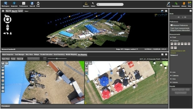
24th October 2017
Orbit GT launches new Feature Extraction product for Drones23rd October 2017
UrtheCast and e-GEOS together offer unique optical and SAR products23rd October 2017
Call for Proposals to develop NSDI Metadata Handbook in Namibia23rd October 2017
A new generation of disruptive property and location data businesses21st October 2017
Hexagon Supports Zurich’s Public Transportation Network21st October 2017
OceanWise Marine Data Management and GIS Workshop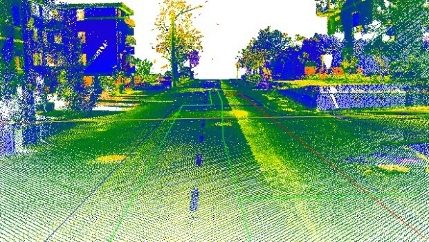
20th October 2017
Maintenance of the utility networks with Mobile Mapping technology18th October 2017
Geospatial Themed BIM Event Debates GIS Data Integration18th October 2017
Enhanced and Improved Functionalities for New Release of Global Mapper18th October 2017
Last SuperSurv 10.0 Update Released, Next: SuperSurv 10.1!17th October 2017
OceanWise Offers Continuity for Marine Mapping Users17th October 2017
Cloud migration path for Cadcorp web mapping16th October 2017
PDF3D work with Forensics to Bring 3D PDF into the Court Room14th October 2017
NavVis partners with PrecisionPoint to bring American indoors online13th October 2017
GSDI Webinar on Open Geospatial Data on 16 November 201712th October 2017
Geospatial World Forum is ‘must-attend’ event says AlphaBeta report12th October 2017
GriBat Consultants Selects SuperPad for Spatial Data Collection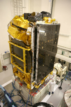
11th October 2017
EUTELSAT 172B satellite reaches geostationary orbit in record time

9th October 2017
Collaboration for Constructioneering Academy initiative
6th October 2017
European Consortium Demonstrates new Internet-of-Things Platform
5th October 2017
Geosoft and AcornSI move UXO classification to the cloud
5th October 2017
OGC Announces New 3D Portrayal Service Standard
3rd October 2017
Satellite Images show Europe's diversity in new book2nd October 2017
Frequentis and Hexagon for Nationwide Integrated Command Centers
2nd October 2017
Approaches and solutions for tomorrow’s transport2nd October 2017
CGG announces overwhelming acceptance by creditors30th September 2017
Free Public Land Survey System (PLSS) Data for Use with Maptitude30th September 2017
Pitney Bowes selects HERE data to aid insurers29th September 2017
Bluesky Tree Map Helps Dudley Protect Urban Trees28th September 2017
Successfully launching the 3rd Annual Smart Parking UAE Conference28th September 2017
Astun Technology Supports Ordnance Survey27th September 2017
INTERGEO 2017 Berlin: Geo-IT-event officially opened26th September 2017
Partnership Offers Analysis Software for Scholarship Winners26th September 2017
ArcGIS Pro Users 'Finding the Best Place for a Public Park'26th September 2017
Commercial UAV Expo Europe Moves to Amsterdam in April, 201826th September 2017
New extras added to Global Mapper V.19 - Now Availale