
_GEO.jpg)
Lincolnshire County Council Implements thinkWhere’s Cloud GIS
21st March 2018
Lincolnshire County Council Implements thinkWhere’s Cloud GIS
Global Mapper and LiDAR Module SDK v19.1 Now Available
21st March 2018
Global Mapper and LiDAR Module SDK v19.1 Now Available
Launching INTERGEO 2018 Geoinformation – the DNA of digitalisation
21st March 2018
Launching INTERGEO 2018 Geoinformation – the DNA of digitalisation
Hexagon Joins British APCO as Platinum Member
21st March 2018
Hexagon Joins British APCO as Platinum Member
Esri Partners Honored at Esri FedGIS Conference
21st March 2018
Esri Partners Honored at Esri FedGIS Conference
Mapmaker AND provides MapFusion to Dutch government
20th March 2018
Mapmaker AND provides MapFusion to Dutch government
Government gives go ahead for Geospatial Apprenticeships
20th March 2018
Government gives go ahead for Geospatial Apprenticeships
SimActive Launches Free Data Processing Service
20th March 2018
SimActive Launches Free Data Processing Service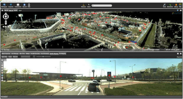
Orbit GT releases 3D Mapping Feature Extraction Pro v18
19th March 2018
Orbit GT releases 3D Mapping Feature Extraction Pro v18
Supergeo Strengthens the Partnership with RASA Surveying
19th March 2018
Supergeo Strengthens the Partnership with RASA Surveying
CGG Adds New Santos VIII Multi-Client Survey
16th March 2018
CGG Adds New Santos VIII Multi-Client SurveyBluesky National Tree Map Helps Tamworth Council Bloom
15th March 2018
Bluesky National Tree Map Helps Tamworth Council Bloom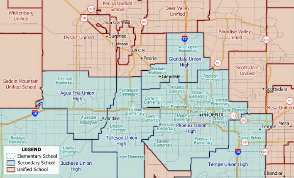
New 2018 School District Data for Maptitude Mapping Software
14th March 2018
New 2018 School District Data for Maptitude Mapping Software
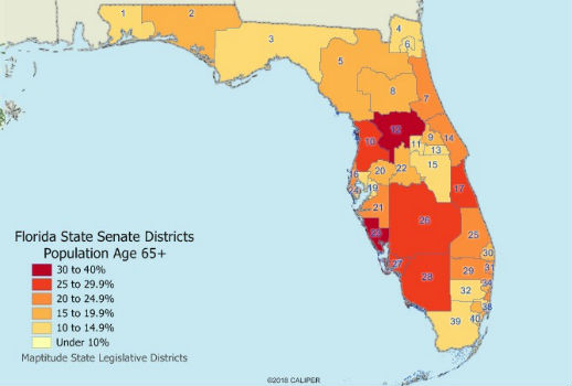
Maptitude 2018 USA Legislative and Congressional Districts
13th March 2018
Maptitude 2018 USA Legislative and Congressional Districts
CGG announces the cooptation of three new board members
9th March 2018
CGG announces the cooptation of three new board members
GeoPlace annual conference to take place on 10th May 2018
9th March 2018
GeoPlace annual conference to take place on 10th May 2018Irish City of the Future Uses Bluesky Aerial Photomaps to Inform Development Plans
8th March 2018
Irish City of the Future Uses Bluesky Aerial Photomaps to Inform Development Plans
Bentley Systems Issues Call for Submissions
8th March 2018
Bentley Systems Issues Call for Submissions
Boundless to Host Roundtable Webinar on Boundless Server Enterprise
8th March 2018
Boundless to Host Roundtable Webinar on Boundless Server Enterprise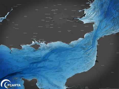
TCarta to Highlight Safety Benefits at Oceanology International 2018
8th March 2018
TCarta to Highlight Safety Benefits at Oceanology International 2018
OGC publishes Testbed 13 Engineering Reports
8th March 2018
OGC publishes Testbed 13 Engineering Reports
Esri Releases Survey123 for ArcGIS with New Spike Integration
8th March 2018
Esri Releases Survey123 for ArcGIS with New Spike Integration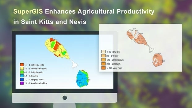
Supergeo Enhances the Agricultural Productivity in St. Kitts and Nevis
8th March 2018
Supergeo Enhances the Agricultural Productivity in St. Kitts and Nevis
Rezatec extends its global reach into Canada
7th March 2018
Rezatec extends its global reach into Canada
OGC joins ApacheCon as Community Partner and Geospatial Track lead
6th March 2018
OGC joins ApacheCon as Community Partner and Geospatial Track lead
Data for Use with Maptitude for entire USA
6th March 2018
Data for Use with Maptitude for entire USA
Avenza Releases MAPublisher 10.1 For Adobe Illustrator
6th March 2018
Avenza Releases MAPublisher 10.1 For Adobe Illustrator
Woodland Managers in Sweden Choose Globalstar’s SPOT Gen3
5th March 2018
Woodland Managers in Sweden Choose Globalstar’s SPOT Gen3
CityEngine Used to Create Oscar-Nominated Effects in Blade Runner 2049
2nd March 2018
CityEngine Used to Create Oscar-Nominated Effects in Blade Runner 2049
OGC seeks public comment on Web Services Security Candidate Standard
2nd March 2018
OGC seeks public comment on Web Services Security Candidate StandardGeoPlace announces launch of 2018 Exemplar Awards
1st March 2018
GeoPlace announces launch of 2018 Exemplar AwardsGeospatial data improves the performance of agriculture
1st March 2018
Geospatial data improves the performance of agriculture

Course on mapping for disaster response and humanitarian projects
1st March 2018
Course on mapping for disaster response and humanitarian projects
South African Nautical Charts Now Available from EVG
28th February 2018
South African Nautical Charts Now Available from EVG
GC seeks public comment on GML in JPEG 2000 (GMLJP2) v2.1
28th February 2018
GC seeks public comment on GML in JPEG 2000 (GMLJP2) v2.1
GeoPlace launches new service to help councils with business rates
28th February 2018
GeoPlace launches new service to help councils with business rates
Esri Acquires ClearTerra Location Data Extraction Technology
26th February 2018
Esri Acquires ClearTerra Location Data Extraction Technology
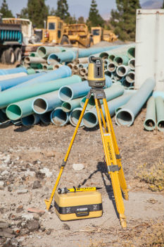
Topcon To Showcase The Latest Automated Workflows
22nd February 2018
Topcon To Showcase The Latest Automated Workflows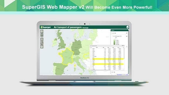
Zero-Coding Web GIS Designer - SuperGIS Web Mapper Update
22nd February 2018
Zero-Coding Web GIS Designer - SuperGIS Web Mapper Update
AND signs map license agreement with Mapbox
16th February 2018
AND signs map license agreement with Mapbox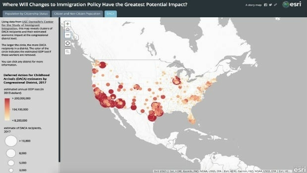
Esri Story Map Explores Communities Impacted by Immigration Changes
15th February 2018
Esri Story Map Explores Communities Impacted by Immigration Changes