NOAA showcases new mapping tool for marine species
2nd May 2022
NOAA showcases new mapping tool for marine speciesComputer-based tools and techniques for the storage, processing, querying and visualisation of geographic data, most notably in the form of maps, charts and atlases
This topic covers the software systems and services– both desktop, mobile and cloud-based - that are used across the public, private and consumer sectors to store, process and display geographic data, most notably in the form of maps, charts and atlases. It also covers the tools provided by such software and cloud-based services to manipulate, analyse and query that data, as well as to integrate a variety of non-spatial datasets. See also Geographic Information Systems (GIS)
2nd May 2022
NOAA showcases new mapping tool for marine species
19th April 2022
CHC Navigation introduces the AlphaAir 1400 and AlphaAir 2400 Airborne LiDAR Series14th April 2022
Esri UK's annual conference returns to London's QEII Centre after two virtual years
12th April 2022
Esri releases updated land-cover map with new sets of global data31st March 2022
Announcing NVIDIA DRIVE Map: Scalable, Multi-Modal Mapping Engine Accelerates Deployment of Level 3 and Level 4 Autonomy30th March 2022
CGG Delivers New Multi-Client Screening Study for Lithium Brines28th March 2022
PlanetObserver Releases the most Beautiful 10m Global Imagery Basemap14th March 2022
Esri Releases Updated Land-Cover Map with New Sets of Global Data9th March 2022
Bentley Systems Announces Availability of Life Cycle Assessment and Embodied Carbon Calculation Capabilities for Infrastructure Digital Twins9th March 2022
CGG Delivers New Multi-Client Study for Screening Geothermal Resources8th March 2022
XMAP GIS Tool Aids UK Government’s £2 Billion Active Travel Schemes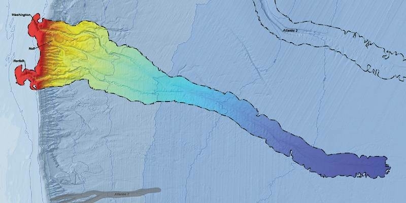
25th February 2022
CSA and BOEM to Publish Online Open-Access Atlas of US Submarine Canyons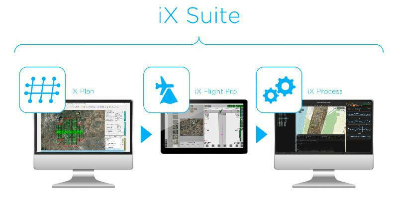
4th February 2022
Phase One Announces iX Suite for Seamless Aerial Mapping Workflow from Flight Planning to Image Delivery
1st February 2022
Oxfordshire Fire and Rescue Service invests in independently performed Risk Modelling27th January 2022
EarthCam 4D Brings Construction Digital Twins to Life18th January 2022
viaEuropa extends premium maps and imagery access to Northern Ireland
25th November 2021
CGG Delivers New Multi-Client Screening Study for CO2 Storage Sites in UK and Norway Northern North Sea
24th November 2021
RIEGL USA Signs New OEM Partner Agreement
19th November 2021
3D PluraView – stereoscopic desktop monitors for military use – shielded and zoned according to NATO standards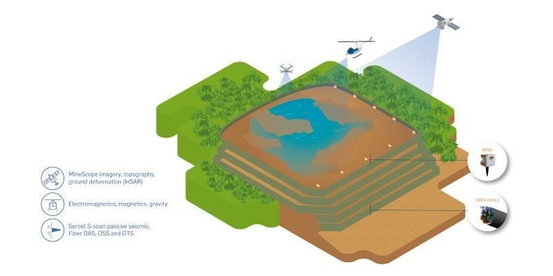
9th November 2021
CGG Launches TailingsPulse Monitoring Solution for Tailings Storage Facilities
8th November 2021
OGC seeks public comment on revision to the OGC Two Dimensional Tile Matrix Set and Tile Set Metadata Standard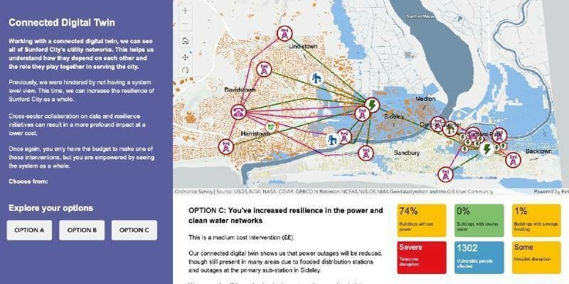
3rd November 2021
National Digital Twin programme launches interactive app and film at COP26
26th October 2021
HERE launches Intelligent Speed Assistance map for automakers to comply with EU regulation
22nd September 2021
HxGN Content Program introduces digital twins of major cities21st September 2021
Bentley Systems Announces Finalists for the 2021 Going Digital Awards in Infrastructure
9th September 2021
Outdooractive UK expands its cartography team ahead of satellite tech advances12th August 2021
Fraunhofer IPM awarded for development of AI tool that creates smart planning maps
11th August 2021
Agisoft Metashape Pro and 3D PluraView monitors enable 3D-stereo photogrammetry at its best
16th July 2021
Esri Releases New Predictive 2050 Global Land Cover Map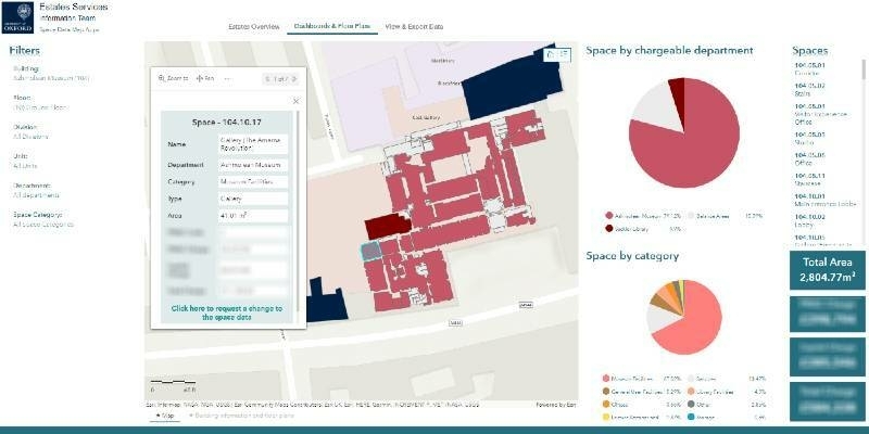
14th July 2021
University of Oxford improves efficiency of estate management with indoor mapping
1st July 2021
Septentrio announces partnership with XenomatiX21st June 2021
NTIA Creates First Interactive Map to Help Public See the Digital Divide Across the Country17th June 2021
RYA Coastal Atlas update to improve protection of recreational boating
14th April 2021
Underground Utility Mapping Workshop with Eos Locate™ for ArcGIS Field Maps
12th March 2021
Property Consultancy Addresses COVID Challenges using thinkWhere Web Mapping Technology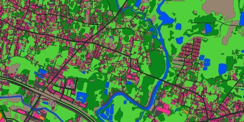
5th March 2021
Ecopia AI and Airbus partnership will provide next-generation digital maps on a global scale
19th February 2021
National Energy System Map contract awarded to 1Spatial and Ordnance Survey by The Energy Networks Association4th February 2021
Bluesky Takes to the Air to Create First Ever 3D Map of Northern Ireland’s Coastline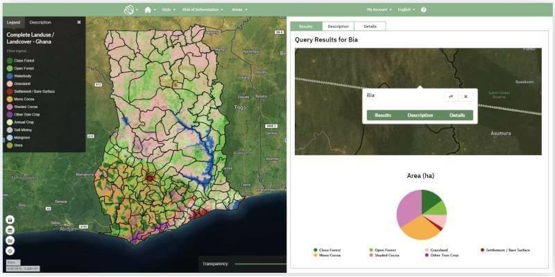
2nd February 2021
Ghana launches National Map of Forests and Land Use
27th January 2021
L3Harris - You're Invited to Spectral Sessions!
14th January 2021
Esri Ireland partners with Bluesky to enhance its digital mapping offering in Ireland
13th January 2021
Ordnance Survey appoints Carly Morris as Head of Geovation
2nd December 2020
The 3D PluraView stereo monitor family – Meeting the highest requirements for Geospatial applications