
Digital Mapping
Computer-based tools and techniques for the storage, processing, querying and visualisation of geographic data, most notably in the form of maps, charts and atlases
This topic covers the software systems and services– both desktop, mobile and cloud-based - that are used across the public, private and consumer sectors to store, process and display geographic data, most notably in the form of maps, charts and atlases. It also covers the tools provided by such software and cloud-based services to manipulate, analyse and query that data, as well as to integrate a variety of non-spatial datasets. See also Geographic Information Systems (GIS)
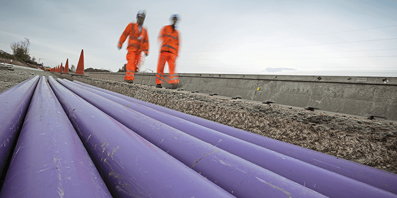
The MUDDI Path Towards a Clearer Underground
1st March 2023
The MUDDI Path Towards a Clearer UndergroundBluesky Tree Map Enhances Online Urban Forest Mapping Platform
24th February 2023
Bluesky Tree Map Enhances Online Urban Forest Mapping Platform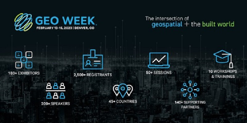
Geo Week features sold-out exhibit floor and 2,500+ registrants
9th February 2023
Geo Week features sold-out exhibit floor and 2,500+ registrantsGeoteric is disrupting the seismic interpretation market in another world-first software release
7th February 2023
Geoteric is disrupting the seismic interpretation market in another world-first software releaseUKHO to extend timetable for paper chart withdrawal
6th February 2023
UKHO to extend timetable for paper chart withdrawalHexagon announces new platform for defense mobile apps
27th January 2023
Hexagon announces new platform for defense mobile apps

Esri UK appoints Pete Wilkinson as new managing director
26th January 2023
Esri UK appoints Pete Wilkinson as new managing director

Europa Technologies reappointed by Scottish Government for premium PSGA services
23rd January 2023
Europa Technologies reappointed by Scottish Government for premium PSGA services
HERE introduces UniMap to revolutionize how maps are created, updated and used
5th January 2023
HERE introduces UniMap to revolutionize how maps are created, updated and usedCzech Railway Administration will use digital maps from Ness built on Hexagon technology
5th January 2023
Czech Railway Administration will use digital maps from Ness built on Hexagon technology
HERE named #1 location platform by Omdia for 6th consecutive year
3rd January 2023
HERE named #1 location platform by Omdia for 6th consecutive year
AI enables more effective humanitarian action by estimating population density
2nd January 2023
AI enables more effective humanitarian action by estimating population density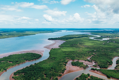
Coastal concerns: how data can help us understand the pressure of climate change
7th December 2022
Coastal concerns: how data can help us understand the pressure of climate changeWeb mapping to support the National Forest’s 25-year vision
6th December 2022
Web mapping to support the National Forest’s 25-year vision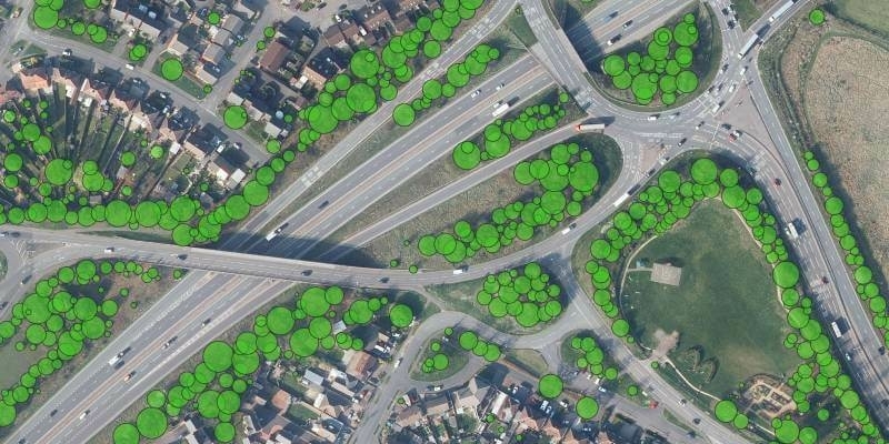
Bluesky Tree Map Protects Leicestershire Highways from Falling Trees
30th November 2022
Bluesky Tree Map Protects Leicestershire Highways from Falling Trees
Esri UK provides mapping expertise for Department for Education’s major new climate project
24th November 2022
Esri UK provides mapping expertise for Department for Education’s major new climate projectFugro awarded major offshore wind contract with Energinet to support Denmark’s renewable energy goals
17th November 2022
Fugro awarded major offshore wind contract with Energinet to support Denmark’s renewable energy goalsTeledyne Optech Galaxy T2000 mobilized for earthquake recovery and reconstruction effort in China
16th November 2022
Teledyne Optech Galaxy T2000 mobilized for earthquake recovery and reconstruction effort in ChinaChange in leadership at GAF AG – Dr Gernot Ramminger named new Managing Director
16th November 2022
Change in leadership at GAF AG – Dr Gernot Ramminger named new Managing DirectorPresagis Teams with Kambill Systems to Provide Artificial Intelligence-Based Geospatial Services in Asia Pacific
15th November 2022
Presagis Teams with Kambill Systems to Provide Artificial Intelligence-Based Geospatial Services in Asia PacificHexagon’s R-evolution enables blue carbon credits for the world’s largest seagrass ecosystem
14th November 2022
Hexagon’s R-evolution enables blue carbon credits for the world’s largest seagrass ecosystem
Open Maps For Europe wins BeGeo Best Project Award
9th November 2022
Open Maps For Europe wins BeGeo Best Project Award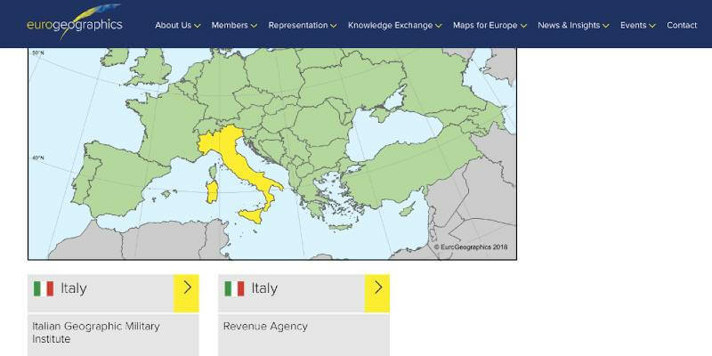
National providers of official geospatial data map out role in EU decade of action
10th October 2022
National providers of official geospatial data map out role in EU decade of action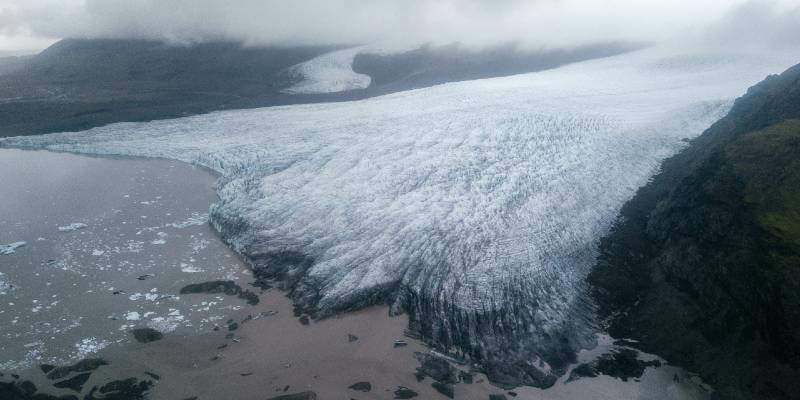
EuroGeographics selected as friend of the EU Mission Adaptation to Climate Change
3rd October 2022
EuroGeographics selected as friend of the EU Mission Adaptation to Climate Change
Esri UK announces new Teach with GIS resources
28th September 2022
Esri UK announces new Teach with GIS resources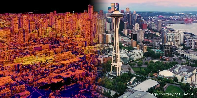
HEAVY.AI Launches Industry’s First Digital Twin for Telco Network Planning, Building and Operations, Leveraging the NVIDIA Omniverse Platform
21st September 2022
HEAVY.AI Launches Industry’s First Digital Twin for Telco Network Planning, Building and Operations, Leveraging the NVIDIA Omniverse Platform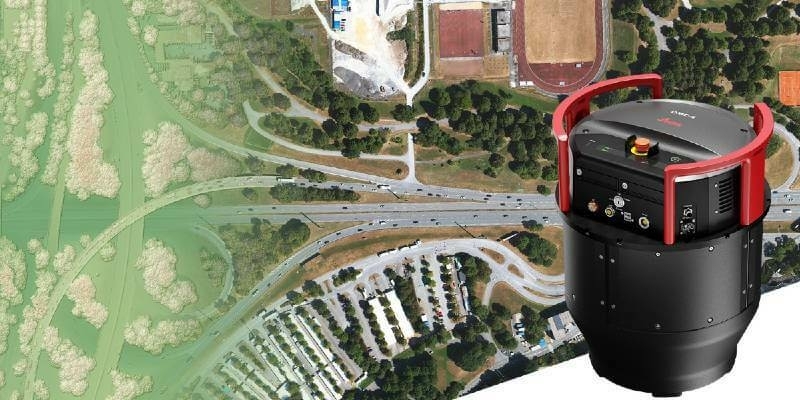
Leica Geosystems announces new Leica DMC-4 airborne imaging sensor delivering superior image fidelity
9th September 2022
Leica Geosystems announces new Leica DMC-4 airborne imaging sensor delivering superior image fidelity
1Spatial Awarded VertiGIS Products Call-Off Contract with Defra
1st September 2022
1Spatial Awarded VertiGIS Products Call-Off Contract with Defra
EuroGeographics welcomes strengthened UN-GGIM
24th August 2022
EuroGeographics welcomes strengthened UN-GGIM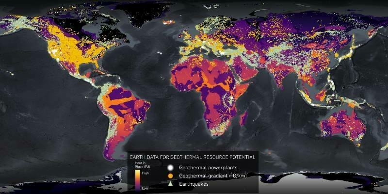
CGG Licenses Geothermal Multi-Client Studies Supporting Energy Transition to US Energy Company
2nd August 2022
CGG Licenses Geothermal Multi-Client Studies Supporting Energy Transition to US Energy Company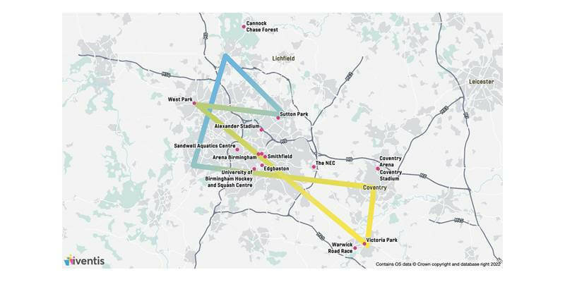
Birmingham 2022 Commonwealth Games selects Iventis as official technology supplier
26th July 2022
Birmingham 2022 Commonwealth Games selects Iventis as official technology supplier
BASEMAP Announces £3.2 Million PSGA Contract with Ordnance Survey
18th July 2022
BASEMAP Announces £3.2 Million PSGA Contract with Ordnance Survey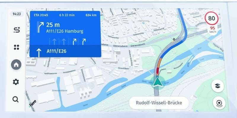
VinFast integrates Intelligent Speed Assistance from HERE Technologies into VF 8 and VF 9
11th July 2022
VinFast integrates Intelligent Speed Assistance from HERE Technologies into VF 8 and VF 9Surrey Heath Improves Public Engagement with XMAP Mapping Portal
28th June 2022
Surrey Heath Improves Public Engagement with XMAP Mapping Portal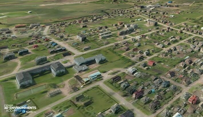
Presagis Extends 3D Tiles Next Workflow into Esri ArcGIS Pro
27th June 2022
Presagis Extends 3D Tiles Next Workflow into Esri ArcGIS Pro
Parish Online Maps a Route to Better Mental Health with Walk N Talk
15th June 2022
Parish Online Maps a Route to Better Mental Health with Walk N Talk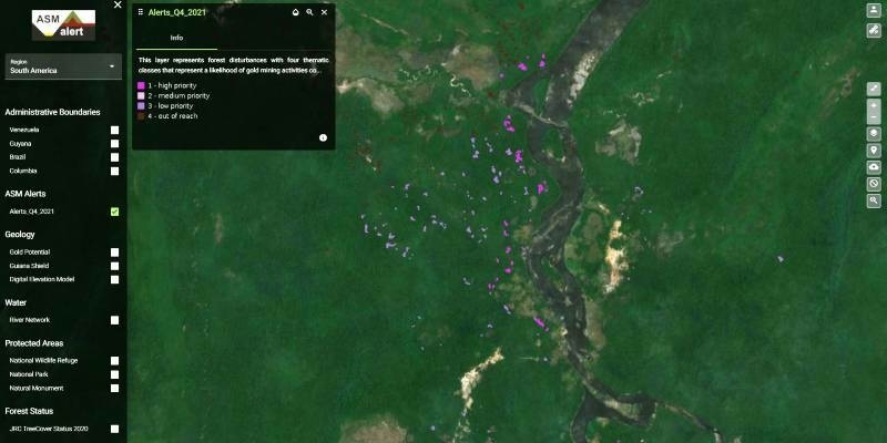
Satellite data help to detect artisanal mining - GAF AG develops the “ASM Alert” web platform
18th May 2022
Satellite data help to detect artisanal mining - GAF AG develops the “ASM Alert” web platform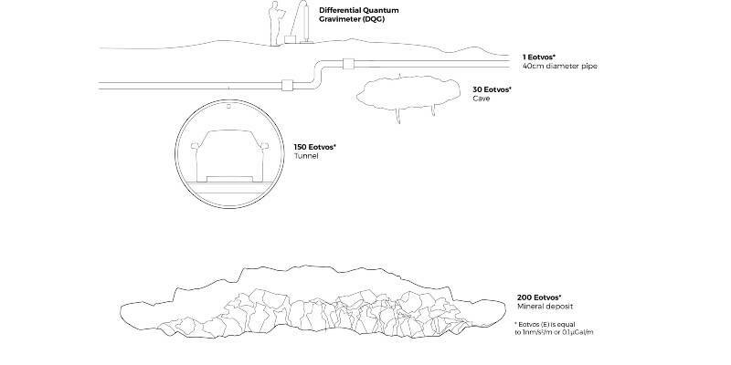
iXblue introduces a new commercial quantum sensor for accurate underground mapping
16th May 2022
iXblue introduces a new commercial quantum sensor for accurate underground mapping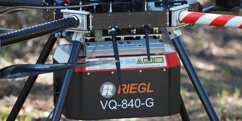
Riegl Australia: Successful Integration Of The VQ-840-G Into Heavy-Lift Industrial Drone
16th May 2022
Riegl Australia: Successful Integration Of The VQ-840-G Into Heavy-Lift Industrial Drone
Petrobras Extends CGG Geovation Seismic Imaging Software Licensing Agreement for Five Years
11th May 2022
Petrobras Extends CGG Geovation Seismic Imaging Software Licensing Agreement for Five Years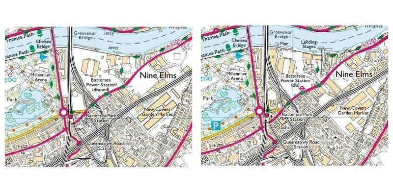
Europa Technologies looks back with viaEuropa “Time Machine”
10th May 2022
Europa Technologies looks back with viaEuropa “Time Machine”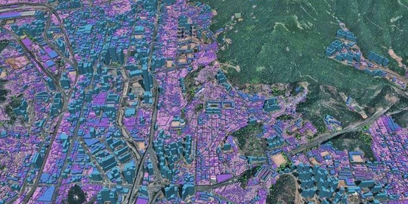
Ecopia AI and Airbus Expand Partnership to Enable Global 3D Vector Mapping
9th May 2022
Ecopia AI and Airbus Expand Partnership to Enable Global 3D Vector Mapping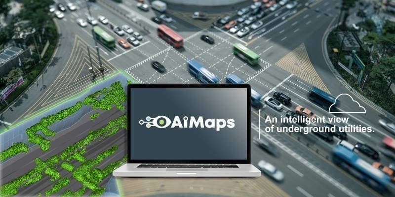
IDS GeoRadar launches cloud-based AI solution AiMaps
5th May 2022
IDS GeoRadar launches cloud-based AI solution AiMapsDigital Twin pioneer Cityzenith highlighted in pivotal Ernst & Young report on Metaverse opportunities
3rd May 2022
Digital Twin pioneer Cityzenith highlighted in pivotal Ernst & Young report on Metaverse opportunities