Cartography
The compilation, reproduction and dissemination of maps and charts by means of manual (analogue) or digital techniques, tools and workflows. This topic covers the compilation, reproduction, dissemination and use of both analogue (paper) and digital maps, charts and atlases. As well as the science of cartography, including georeferencing and geocoding, digital techniques for compiling and generating various types of raster and vector maps and charts are covered, as are the digital mapping tools and Geographic Information Systems available for this purpose. The application of cartography for aeronautical, terrestrial and marine purposes is also covered

New Trimble Technology Lab Gift to UMass Amherst
26th January 2017
New Trimble Technology Lab Gift to UMass Amherst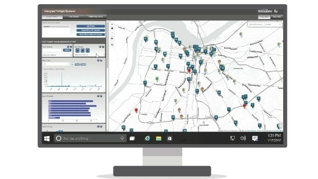
Hexagon Safety & Infrastructure Launches New Police Analytics Software
26th January 2017
Hexagon Safety & Infrastructure Launches New Police Analytics Software
Orbit GT and Shanghai Topcon-Sokkia (STS), sign Reseller Agreement
26th January 2017
Orbit GT and Shanghai Topcon-Sokkia (STS), sign Reseller Agreement
Next-Generation Geolocation for IoT from Abeeway and Actility
26th January 2017
Next-Generation Geolocation for IoT from Abeeway and Actility
Kullasoft release the Android version of the PGM Manager app
26th January 2017
Kullasoft release the Android version of the PGM Manager app
OGC Calls for Participation in Major Innovation Testbed (Testbed 13)
26th January 2017
OGC Calls for Participation in Major Innovation Testbed (Testbed 13)
High-Speed Connectivity to Civilian Armored Vehicles
25th January 2017
High-Speed Connectivity to Civilian Armored Vehicles
Abstract Submissions Invited for GIS-Pro 2017 in Jacksonville, Florida
25th January 2017
Abstract Submissions Invited for GIS-Pro 2017 in Jacksonville, Florida

IMCA Guidance Demonstrates the Strength of Working Together
25th January 2017
IMCA Guidance Demonstrates the Strength of Working Together
New project to boost Sat Nav positioning accuracy anywhere in world
25th January 2017
New project to boost Sat Nav positioning accuracy anywhere in world
In focus: The state of sewer management system technology
25th January 2017
In focus: The state of sewer management system technology
New measurement solution for optimization of LTE / 4G networks
25th January 2017
New measurement solution for optimization of LTE / 4G networks
40 Years of Educating Communications Technology Professionals
25th January 2017
40 Years of Educating Communications Technology Professionals
PCI Selects Sole Authorized Reseller in Ecuador
25th January 2017
PCI Selects Sole Authorized Reseller in Ecuador
COSMO-SkyMed data and services for the Japanese government
25th January 2017
COSMO-SkyMed data and services for the Japanese government
Pix4D speaks at UN Panel on Food Security
25th January 2017
Pix4D speaks at UN Panel on Food Security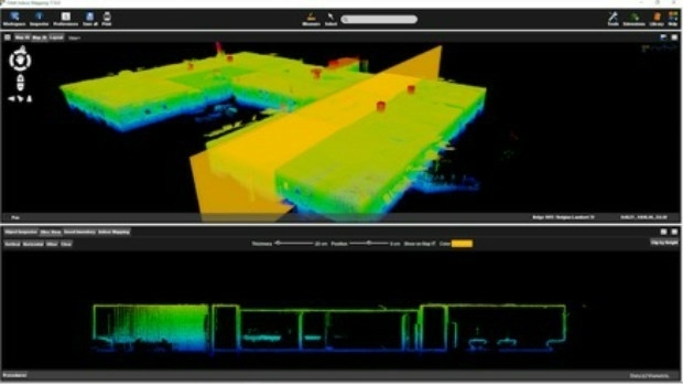
Orbit GT releases Indoor Mapping solution with Floor Plan Builder
25th January 2017
Orbit GT releases Indoor Mapping solution with Floor Plan Builder
Propulsion test module for the Orion programme delivered to NASA
25th January 2017
Propulsion test module for the Orion programme delivered to NASA
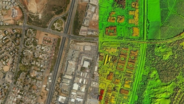
Airport GIS | LiDAR, imagery and feature extraction for airport operations
24th January 2017
Airport GIS | LiDAR, imagery and feature extraction for airport operationsTomTom and Mappy extend their long-term relationship
24th January 2017
TomTom and Mappy extend their long-term relationship
TrackR launches updated Find My Phone Skill for Amazon Alexa
23rd January 2017
TrackR launches updated Find My Phone Skill for Amazon Alexa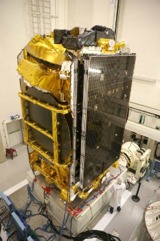
Seabed Geosolutions Mobilises For OBN Survey In West Africa
20th January 2017
Seabed Geosolutions Mobilises For OBN Survey In West Africa
AGI and Bentley Systems Announce Cesium Consortium
20th January 2017
AGI and Bentley Systems Announce Cesium Consortium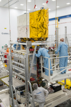
Airbus ready to ship Aeolus for final testing ahead of launch
20th January 2017
Airbus ready to ship Aeolus for final testing ahead of launchGeosoft and Minalytix partner to bring MX Deposit to the marketplace
20th January 2017
Geosoft and Minalytix partner to bring MX Deposit to the marketplace
URISA 2017 Exemplary Systems in Government Awards Process Opens
19th January 2017
URISA 2017 Exemplary Systems in Government Awards Process Opens
Dates and Venues Unveiled For GeoDATA 2017 Showcase Series
19th January 2017
Dates and Venues Unveiled For GeoDATA 2017 Showcase Series
Map maker AND releases ZIP+4 Code Boundaries for the USA
19th January 2017
Map maker AND releases ZIP+4 Code Boundaries for the USA
Airbus provides satellite communications for the French administration
19th January 2017
Airbus provides satellite communications for the French administration1Spatial & National Trust Streamline Agricultural Grant Process
19th January 2017
1Spatial & National Trust Streamline Agricultural Grant Process
Global Telesat Communications sold 10,000 SPOT Satellite Devices
19th January 2017
Global Telesat Communications sold 10,000 SPOT Satellite Devices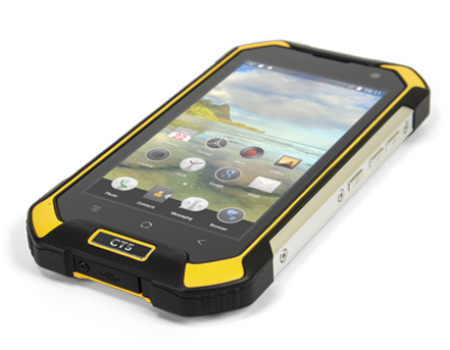
New CT5 Rugged Smartphone Launched from Cedar by Juniper Systems
19th January 2017
New CT5 Rugged Smartphone Launched from Cedar by Juniper Systems
Abstract Submissions for 10th National GIS in Transit Conference
18th January 2017
Abstract Submissions for 10th National GIS in Transit Conference
OGC seeks public comment on OGC WaterML 2 - Part 3
18th January 2017
OGC seeks public comment on OGC WaterML 2 - Part 3
Elsevier Adds More Than One Million Figures and Tables to Geofacets
18th January 2017
Elsevier Adds More Than One Million Figures and Tables to Geofacets
Optimising the design for the Aberdeen Harbour expansion
18th January 2017
Optimising the design for the Aberdeen Harbour expansion
PTV Group opens its first branch office in Africa
18th January 2017
PTV Group opens its first branch office in Africa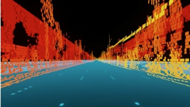
TomTom acquires Autonomos, a Berlin-based autonomous driving start-up
18th January 2017
TomTom acquires Autonomos, a Berlin-based autonomous driving start-up
RICS Geomatics Evening Lectures 2016-17 sessions
18th January 2017
RICS Geomatics Evening Lectures 2016-17 sessions
Esri Releases Advanced Analytics to Increase Retail Sales
18th January 2017
Esri Releases Advanced Analytics to Increase Retail Sales