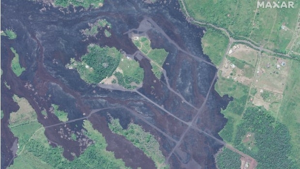
Satellite Imagery: Hawaii One Year After Kilauea Eruption
15th May 2019
Satellite Imagery: Hawaii One Year After Kilauea EruptionThe compilation, reproduction and dissemination of maps and charts by means of manual (analogue) or digital techniques, tools and workflows. This topic covers the compilation, reproduction, dissemination and use of both analogue (paper) and digital maps, charts and atlases. As well as the science of cartography, including georeferencing and geocoding, digital techniques for compiling and generating various types of raster and vector maps and charts are covered, as are the digital mapping tools and Geographic Information Systems available for this purpose. The application of cartography for aeronautical, terrestrial and marine purposes is also covered
15th May 2019
Satellite Imagery: Hawaii One Year After Kilauea Eruption
14th May 2019
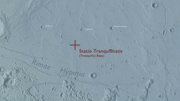
Ordnance Survey map commemorates 1969 moon landing14th May 2019
OGC seeks public comment on update to GeoTIFF standard14th May 2019
EUMETSAT, Japanese space agency to cooperate on greenhouse gas monitoring14th May 2019
CGG Begins First Multi-Client Ocean Bottom Node Survey
14th May 2019
IQGeo launches ‘reality-centric’ geospatial platform14th May 2019
The Israeli Navy Deployed its HELRAS equipped Seagull14th May 2019
Bentley Systems Announces the Acquisition of Keynetix14th May 2019
Future of Mining EMEA arrives in London with the focus on technology,14th May 2019
Bentley Systems Announces Availability of OpenSite Designer14th May 2019
SimActive Software Enables Processing of Wingtra Drone Data14th May 2019
Bentley Systems Announces the Availability of OpenBuildings Station Designer14th May 2019
PCI Geomatics to showcase Analysis Ready Data tools13th May 2019
AND appoints DDS as reseller of the AND Digital Maps
13th May 2019
Bluesky and Skyline Create Dynamic 3D City Models10th May 2019
2019 State Legislative District & Congressional District Boundaries10th May 2019
Unifly in top three 'hottest' European scale-ups at TNW Conference 201910th May 2019
New digital maps available for Germany, Austria and Switzerland10th May 2019
Terra Drone opens Angola branch due to high demand from oil and gas industry9th May 2019
Ocean Business Celebrates International Success9th May 2019
Terra Drone India surveys 4,200 sq km in Maharashtra9th May 2019
Garmin receives approval for the GFC 500 autopilot in the Mooney M20
9th May 2019
thinkWhere Raises Crucial Funds for MapAction8th May 2019
Rene Worms joins Atmos UAV as Head of Global Sales8th May 2019
Workshop and Presentation Proposals Invited for #GIS/ValTech20208th May 2019
Infrastructure Inspection – UAS Are All Over It8th May 2019
Maptitude Mapping Software Team Provides Awards & Prizes for 2019 AAG8th May 2019
CSA Completes Field Surveys Offshore Puerto Rico7th May 2019
TCarta teams up with King’s College London and wins ESA Funding7th May 2019
Engineering Reports and Videos documenting successful Vector Tiles Pilot7th May 2019
HERE powers new serverless location-based functions7th May 2019
PTV Group's new route planning app now available on Salesforce AppExchange7th May 2019
Firefighting drones are the future of fire safety