Global Mapper v.20.1 Now Available with Path Profile Zooming
26th February 2019
Global Mapper v.20.1 Now Available with Path Profile ZoomingThe compilation, reproduction and dissemination of maps and charts by means of manual (analogue) or digital techniques, tools and workflows. This topic covers the compilation, reproduction, dissemination and use of both analogue (paper) and digital maps, charts and atlases. As well as the science of cartography, including georeferencing and geocoding, digital techniques for compiling and generating various types of raster and vector maps and charts are covered, as are the digital mapping tools and Geographic Information Systems available for this purpose. The application of cartography for aeronautical, terrestrial and marine purposes is also covered
26th February 2019
Global Mapper v.20.1 Now Available with Path Profile Zooming26th February 2019
Commercial UAV Expo Americas Announces Massive Support26th February 2019
Trimble Announces Next Generation Mixed-Reality Device26th February 2019
Routescene Inc. drone based LiDAR system26th February 2019
OGC invites you to participate in its Maritime Limits and Boundaries Pilot26th February 2019
Hexagon Acquires Thermopylae Sciences & Technology26th February 2019
thinkWhere Helps Atholl Estates Transition to QGIS25th February 2019
Hexagon advances its 5D visualisation portfolio25th February 2019
HERE to offer mapping and location services for China25th February 2019
Bentley Systems Introduces Mixed Reality App25th February 2019
Selected for Maryland's Online Redistricting Mapping Portal25th February 2019
Blockchain and Distributed Ledger Technologies (BDLT) Domain Working Group22nd February 2019
RDO becomes first WingtraOne drone Certified Repair Center22nd February 2019
Satellite building on an entirely new scale22nd February 2019
OceanWise are running a Scottish Marine Data and GIS Workshop22nd February 2019
Danish Geodata Agency Partners with Esri21st February 2019
Terra Drone brings proven UAS solutions to India21st February 2019
Internet of Things Applications Europe 201921st February 2019
OceanTech Program (OT 2019), Zhoushan, China20th February 2019
New map from HERE Technologies shows quality of cell phone coverage20th February 2019
Topcon GLS-2000 scanner update enhances data capture20th February 2019
Improves Accuracy On Replica Grade 1 Listed Building Redevelopment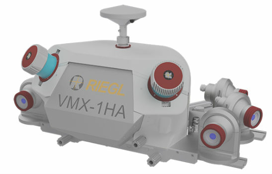
19th February 2019
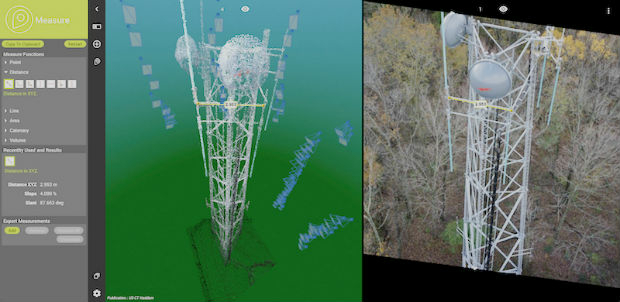
COMPLETE MOBILE SURVEYING OF AMTRAK’S NEW YORK PENN STATION19th February 2019
Airbus turns imagery into insight with The OneAtlas Platform19th February 2019
American Red Cross to present at Esri UK AC19th February 2019
Nanotron and ClearBlade partner to deliver 360° Edge Analytics19th February 2019
IN-FLIGHT Data awarded three GUINNESS WORLD RECORDS™19th February 2019
Juniper Systems Limited Launches New Cedar CT8 Rugged Tablet18th February 2019
Garmin® celebrates a GPS milestone in aviation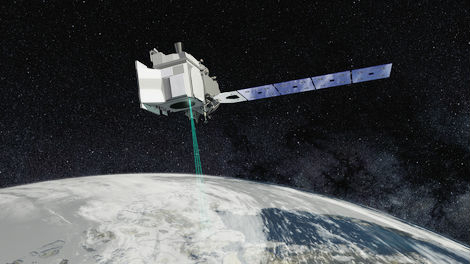
18th February 2019
Mapping and Monitoring the Carbon Content of Earth’s Forests16th February 2019
Offshore Survey 2019 Launches Technology Packed Programme15th February 2019
Topcon introduces GT-503M motorised total station
15th February 2019
New radar systems enable quick integration