
Cartography
The compilation, reproduction and dissemination of maps and charts by means of manual (analogue) or digital techniques, tools and workflows. This topic covers the compilation, reproduction, dissemination and use of both analogue (paper) and digital maps, charts and atlases. As well as the science of cartography, including georeferencing and geocoding, digital techniques for compiling and generating various types of raster and vector maps and charts are covered, as are the digital mapping tools and Geographic Information Systems available for this purpose. The application of cartography for aeronautical, terrestrial and marine purposes is also covered

GfK releases 2016 purchasing power for Austria and Switzerland
13th April 2016
GfK releases 2016 purchasing power for Austria and Switzerland
Topcon announces new machine control dealer in Italy
13th April 2016
Topcon announces new machine control dealer in Italy
CNES selects Airbus D&S to build instrument for MicroCarb
13th April 2016
CNES selects Airbus D&S to build instrument for MicroCarb
Hemisphere GNSS Announces Partnership Expansion with CPAC Systems AB
13th April 2016
Hemisphere GNSS Announces Partnership Expansion with CPAC Systems AB
Leica Geosystems and Spheron-VR collaborate
13th April 2016
Leica Geosystems and Spheron-VR collaborate
OGC seeks public comment on CDB Candidate Standard
12th April 2016
OGC seeks public comment on CDB Candidate Standard
Forging Marine Improvements through Strategic Partnership
12th April 2016
Forging Marine Improvements through Strategic Partnership
Golden Software Releases Raster Tools, an Add-in for Esri® ArcMap
12th April 2016
Golden Software Releases Raster Tools, an Add-in for Esri® ArcMap
ISPRS awards Prof. Wolfgang Foerstner with Brock Gold Medal
12th April 2016
ISPRS awards Prof. Wolfgang Foerstner with Brock Gold Medal
[EARSC] Survey into Public Service Bodies using EO data and services
12th April 2016
[EARSC] Survey into Public Service Bodies using EO data and services
AVEVA showcases the Future of Steel Fabrication in North America
12th April 2016
AVEVA showcases the Future of Steel Fabrication in North America
Topcon announces monitoring partnership with VMT GmbH
12th April 2016
Topcon announces monitoring partnership with VMT GmbH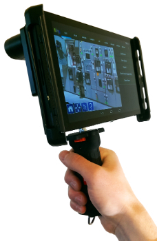
Leica Geosystems partners with DotProduct LLC, SpheronVR AG
12th April 2016
Leica Geosystems partners with DotProduct LLC, SpheronVR AG
Inmarsat selects Kontron as key supplier for European Aviation Network
12th April 2016
Inmarsat selects Kontron as key supplier for European Aviation Network
MICROMINE 2016 to be launched in May with new and exciting features
12th April 2016
MICROMINE 2016 to be launched in May with new and exciting features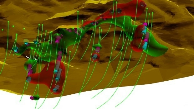
Maptek releases Vulcan 10 incorporating new Workbench platform
12th April 2016
Maptek releases Vulcan 10 incorporating new Workbench platform
Maryland SHA using broadcast quality camera in Furgo vehicle
11th April 2016
Maryland SHA using broadcast quality camera in Furgo vehicle
Orbit GT launches new UAS Mapping software at SPAR, Houston.
11th April 2016
Orbit GT launches new UAS Mapping software at SPAR, Houston.
Cambridge collaboration to launch online platform mapping agribusiness
11th April 2016
Cambridge collaboration to launch online platform mapping agribusiness
Navmii announces Share my Trip feature with 3.5 app update
11th April 2016
Navmii announces Share my Trip feature with 3.5 app update
Topcon introduces next generation machine control
11th April 2016
Topcon introduces next generation machine control
Orbit GT shows automated Feature Extraction tools at SPAR, Houston.
11th April 2016
Orbit GT shows automated Feature Extraction tools at SPAR, Houston.
The Most Rugged Windows Tablet in the World is Now Shipping
8th April 2016
The Most Rugged Windows Tablet in the World is Now Shipping
Transport and logistics resources for schools from CILT and the GA
8th April 2016
Transport and logistics resources for schools from CILT and the GAKilletSoft realizes Polygonal Validity Scopes in NTv2 grid files
8th April 2016
KilletSoft realizes Polygonal Validity Scopes in NTv2 grid files
Public comment on update of OGC Abstract Specification Topic 11
7th April 2016
Public comment on update of OGC Abstract Specification Topic 11
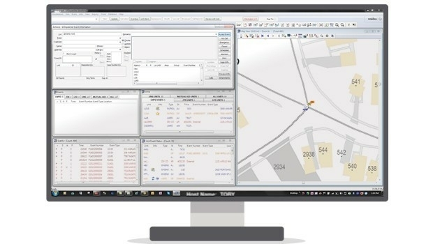
Kansas City Police Selects Hexagon Safety & Infrastructure Software
7th April 2016
Kansas City Police Selects Hexagon Safety & Infrastructure Software
PTV Group offers a virtual world to test future automotive development
7th April 2016
PTV Group offers a virtual world to test future automotive development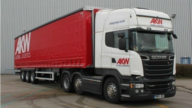
AKW Global Logistics teams up with Intelligent Telematics
7th April 2016
AKW Global Logistics teams up with Intelligent Telematics
Leica Geosystems smart antenna provides superior performance
7th April 2016
Leica Geosystems smart antenna provides superior performance
Esri Announces 2016 Storytelling with Maps Contest
6th April 2016
Esri Announces 2016 Storytelling with Maps Contest
GeoPlace endorses transformational power of addresses and street data
6th April 2016
GeoPlace endorses transformational power of addresses and street data
Maptitude Team Provides Sponsorship for NEGIS Spring Conference
6th April 2016
Maptitude Team Provides Sponsorship for NEGIS Spring Conference
The next AGI ECN webinar is 12th April 2016!
6th April 2016
The next AGI ECN webinar is 12th April 2016!
The new version 6.1 of the PHOTOMOD software family has been released
6th April 2016
The new version 6.1 of the PHOTOMOD software family has been released
Seafloor Delivers Autonomous Multibeam Survey System To Skanska
6th April 2016
Seafloor Delivers Autonomous Multibeam Survey System To Skanska
CYBERBIT Awarded Intelligence and Cyber System Contract in Africa
6th April 2016
CYBERBIT Awarded Intelligence and Cyber System Contract in Africa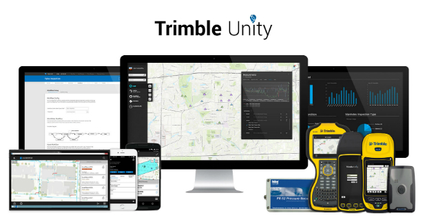
Trimble Launches New Version of its Smart Water Management Software
6th April 2016
Trimble Launches New Version of its Smart Water Management Software
Caliper Offers 2016 Census Block Groups Data
6th April 2016
Caliper Offers 2016 Census Block Groups Data
Improved Mine Planning Software in Spring release
6th April 2016
Improved Mine Planning Software in Spring release
Esri Places in Top Ten of Forbes 2016 Best Midsize Employers
6th April 2016
Esri Places in Top Ten of Forbes 2016 Best Midsize Employers
IDV Solutions launches Visual Command Center 5.0
6th April 2016
IDV Solutions launches Visual Command Center 5.0