
Maptitude 2019 Adds Enhanced MapPoint and Streets & Trips Features
18th May 2019
Maptitude 2019 Adds Enhanced MapPoint and Streets & Trips Features
Orbit GT to exhibit and present at GeoBusiness, London, UK
17th May 2019
Orbit GT to exhibit and present at GeoBusiness, London, UK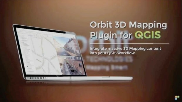
Orbit GT launches 3D Mapping portfolio v19.5 and QGIS plugin update.
17th May 2019
Orbit GT launches 3D Mapping portfolio v19.5 and QGIS plugin update.
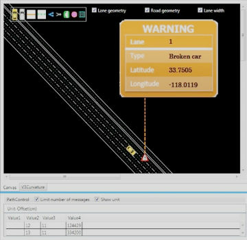
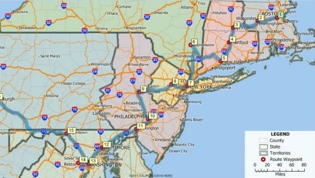
Mitsubishi Electric and HERE develop road hazard alert system
15th May 2019
Mitsubishi Electric and HERE develop road hazard alert system
IQGeo launches ‘reality-centric’ geospatial platform
14th May 2019
IQGeo launches ‘reality-centric’ geospatial platform
Bentley Systems Announces Availability of OpenSite Designer
14th May 2019
Bentley Systems Announces Availability of OpenSite Designer
Bentley Systems Announces the Availability of OpenBuildings Station Designer
14th May 2019
Bentley Systems Announces the Availability of OpenBuildings Station Designer
AND appoints DDS as reseller of the AND Digital Maps
13th May 2019
AND appoints DDS as reseller of the AND Digital Maps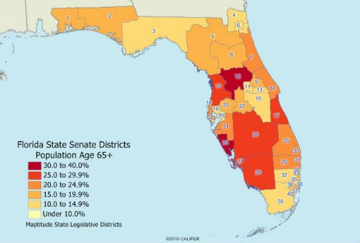
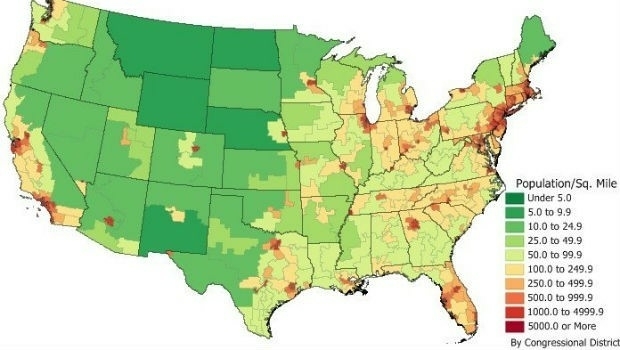
2019 State Legislative District & Congressional District Boundaries
10th May 2019
2019 State Legislative District & Congressional District Boundaries
New digital maps available for Germany, Austria and Switzerland
10th May 2019
New digital maps available for Germany, Austria and Switzerland

Maptitude Mapping Software Team Provides Awards & Prizes for 2019 AAG
8th May 2019
Maptitude Mapping Software Team Provides Awards & Prizes for 2019 AAG
HERE powers new serverless location-based functions
7th May 2019
HERE powers new serverless location-based functions
Caliper Offers 2019 Census Block Groups Data
7th May 2019
Caliper Offers 2019 Census Block Groups Data
Esri releases ArcGIS 10.7 unifying Esri software and services
6th May 2019
Esri releases ArcGIS 10.7 unifying Esri software and services
Orbit GT and TCract, France, sign Reseller Agreement
6th May 2019
Orbit GT and TCract, France, sign Reseller Agreement
Free Highway Exits & Interchanges Data for Use with Maptitude 2019
1st May 2019
Free Highway Exits & Interchanges Data for Use with Maptitude 2019
Europa Technologies announces v2019.1 of premier global data products
30th April 2019
Europa Technologies announces v2019.1 of premier global data products
What’s behind the ground-breaking 3D habitat map of the Great Barrier Reef?
30th April 2019
What’s behind the ground-breaking 3D habitat map of the Great Barrier Reef?
Ordnance Survey and partners to create pilot map of the North East
29th April 2019
Ordnance Survey and partners to create pilot map of the North East
Four Ways Maptitude 2019 Saves You Time & Money
23rd April 2019
Four Ways Maptitude 2019 Saves You Time & Money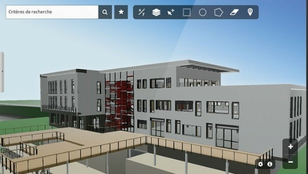
Innovation CARL Software presents its new solutions for operational BIM
23rd April 2019
Innovation CARL Software presents its new solutions for operational BIM
Blue Marble’s Global Mapper Mobile App Now Available
17th April 2019
Blue Marble’s Global Mapper Mobile App Now Available
Esri's Participation in Dubai's Future Cities Show 2019
13th April 2019
Esri's Participation in Dubai's Future Cities Show 2019
HERE launches XYZ: mapmaking and geospatial data management
10th April 2019
HERE launches XYZ: mapmaking and geospatial data management
2010 Census Data and 2017 ACS Data for Use with Maptitude
5th April 2019
2010 Census Data and 2017 ACS Data for Use with Maptitude
2019 EuroSDR Award for the best PhD thesis related to geoinformation science
1st April 2019
2019 EuroSDR Award for the best PhD thesis related to geoinformation science
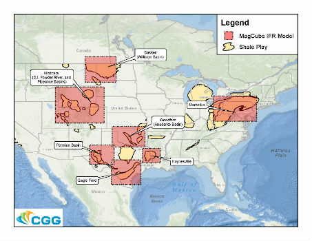
CGG GeoSoftware Supports Geoscience Training
28th March 2019
CGG GeoSoftware Supports Geoscience Training
Kaarta announces $6.5M in Series A Financing
25th March 2019
Kaarta announces $6.5M in Series A Financing
Kinesis Vehicle Tracking Gets Smart with Alexa Integration
20th March 2019
Kinesis Vehicle Tracking Gets Smart with Alexa Integration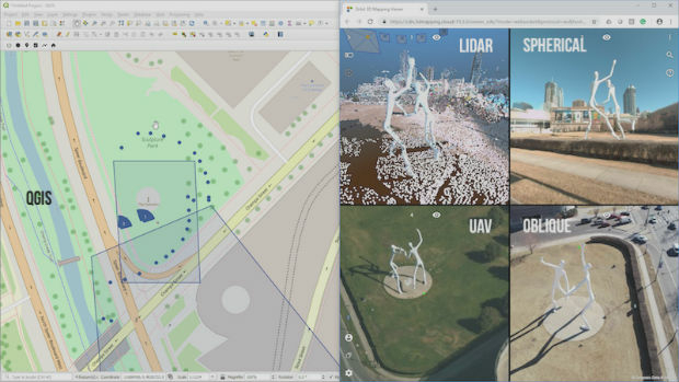
Orbit GT releases SDK and QGIS Plugin v19.3
19th March 2019
Orbit GT releases SDK and QGIS Plugin v19.3
Interactive, fully immersive 3D buildings online
19th March 2019
Interactive, fully immersive 3D buildings online
Orbit GT selected in Top 5 for Smart Territories award at BIM World, Paris
18th March 2019
Orbit GT selected in Top 5 for Smart Territories award at BIM World, Paris
The country’s most detailed map of roads and footways unveiled
13th March 2019
The country’s most detailed map of roads and footways unveiled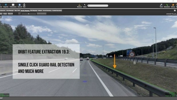
Orbit GT releases version 19.3 of its 3D Mapping portfolio
13th March 2019
Orbit GT releases version 19.3 of its 3D Mapping portfolio
Berlin Airport Now Provides Mobile Wayfinding To Guide Travelers!
12th March 2019
Berlin Airport Now Provides Mobile Wayfinding To Guide Travelers!
Esri to participate in Buffalo Civic Innovation Eco Challenge
7th March 2019
Esri to participate in Buffalo Civic Innovation Eco Challenge
Cityworks Recognized for Exceptional Partnerships at Esri Partner Conference
5th March 2019
Cityworks Recognized for Exceptional Partnerships at Esri Partner Conference
Exceptional Achievement at Partner Conference
4th March 2019
Exceptional Achievement at Partner Conference