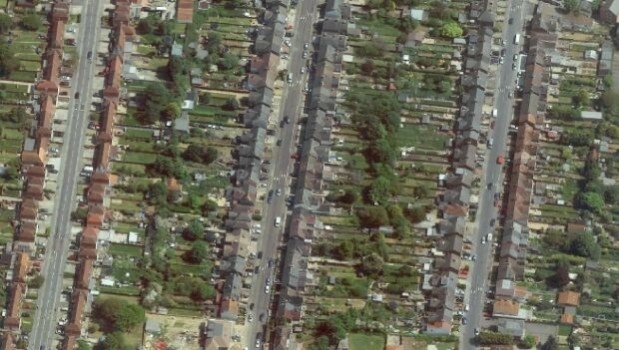
Eye-in-the-sky crackdown on illegal outbuildings
30th July 2013
Eye-in-the-sky crackdown on illegal outbuildingsAerial imaging is revolutionizing the way we capture, analyze, and utilize geospatial data. Using high-resolution aerial photography and remote sensing technologies, it provides accurate and detailed visual information essential for mapping, environmental monitoring, infrastructure planning, and disaster response.
Modern aerial imaging solutions include manned aircraft, UAVs (drones), and satellite-based systems equipped with advanced sensors such as LiDAR, multispectral, and hyperspectral cameras. These technologies enable high-precision mapping, 3D terrain modeling, change detection, and real-time geospatial analysis, supporting industries such as urban planning, agriculture, forestry, defense, and construction.
With cloud-based processing, AI-powered image analysis, and real-time data streaming, aerial imaging continues to advance, offering faster, more accurate, and scalable solutions for GIS professionals and decision-makers.
GeoConnexion provides the latest insights on aerial imaging trends, innovations, and applications, helping professionals leverage aerial data for better spatial intelligence and operational efficiency.
30th July 2013
Eye-in-the-sky crackdown on illegal outbuildings13th June 2013
Safe Cities - Proactive Approach to Flood Management13th June 2013
The changing expectations for backup and disaster recovery4th February 2013
Improved Asset Performance seen as top challenge for Infrastructure Asset Management Professionals
22nd November 2012
Germany consolidates its position in European space
14th September 2012
Corpus Christi, Texas Steps into 3D GeoDesign and Emerges a Winner