3D Modelling
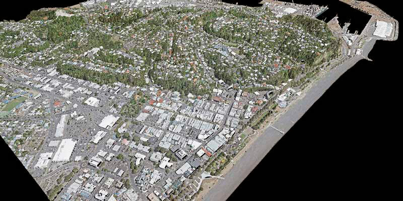
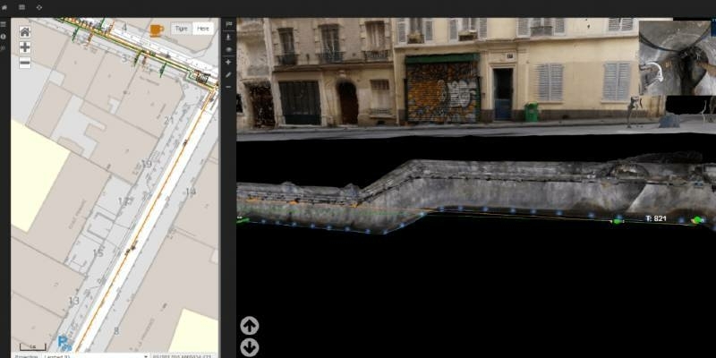
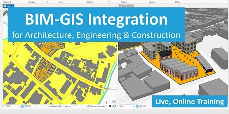
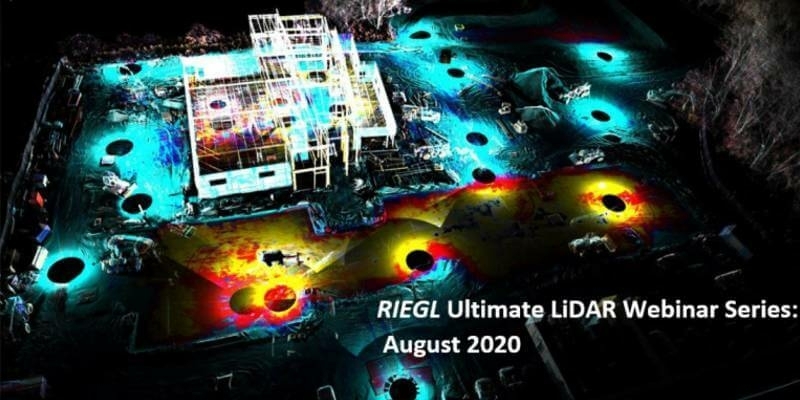
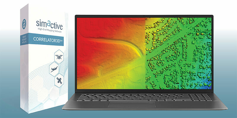
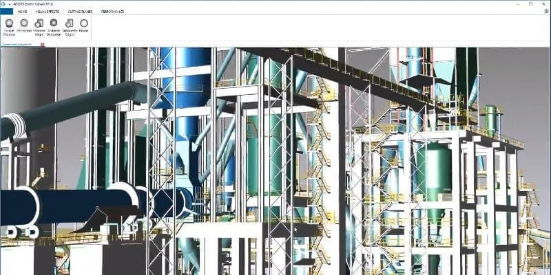
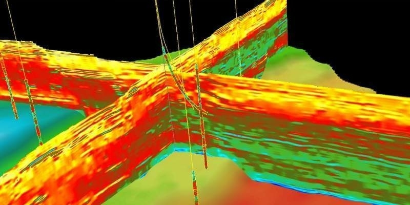
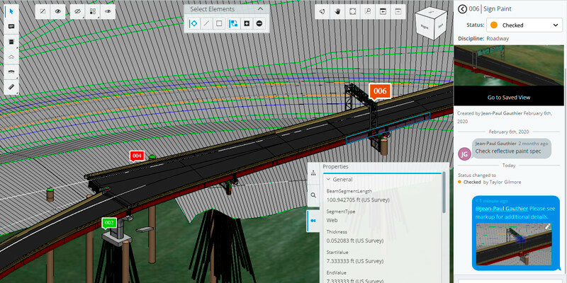
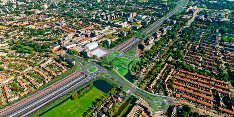
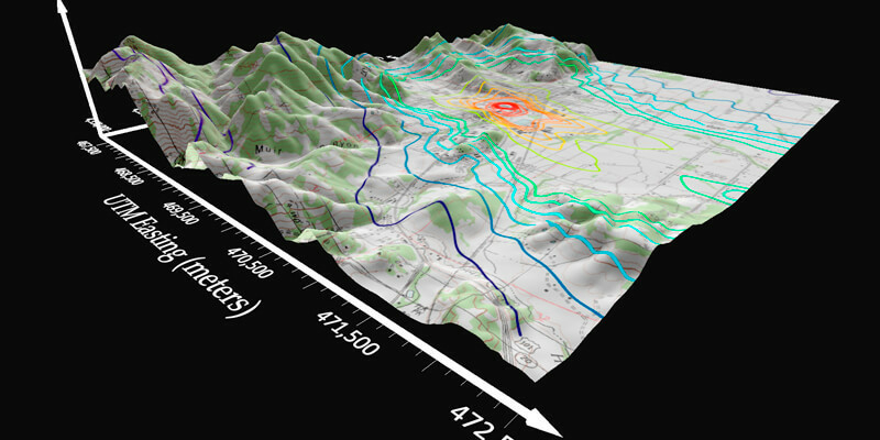
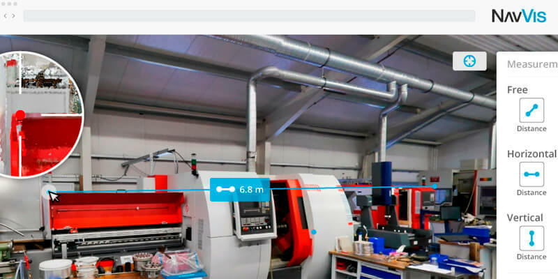
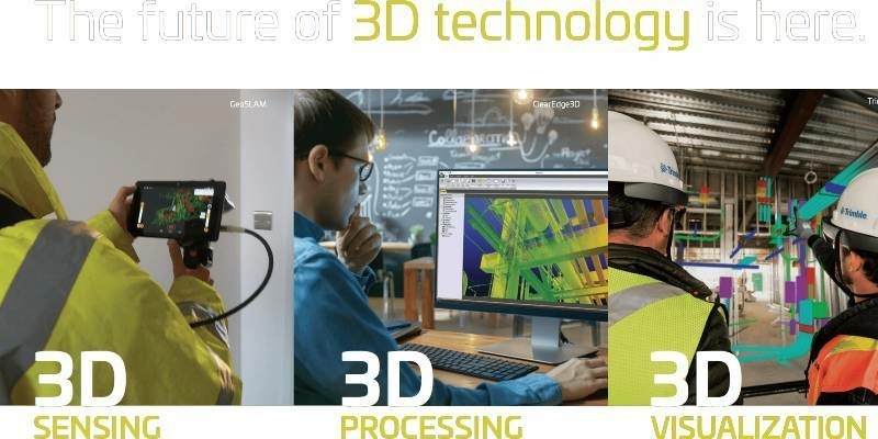
The creation, visualisation and use of three-dimensional representations of real or virtual world terrains, surfaces, elevations and built objects
Three-dimensional models are used increasingly in the public and private sectors and in academic research to visualise and analyse real or virtual world features and objects. This topic encompasses the creation of 3D geometric models from captured spatial data and their use in applications that include architecture, construction, engineering, urban planning, city and infrastructure modelling, transport and utility network planning and management, asset management, entertainment film production, video gaming and the geosciences. Additionally, the topic covers the creation and use of 3D models that make use of Virtual, Augmented and Mixed Reality techniques
Cityscape and Bluesky MetroVista 3D Models Bring Virtual Reality to the Property Sector
26th August 2020
Cityscape and Bluesky MetroVista 3D Models Bring Virtual Reality to the Property Sector
iXblue, Woolpert partner to deliver LiDAR mapping services to New Zealand Councils
26th August 2020
iXblue, Woolpert partner to deliver LiDAR mapping services to New Zealand Councils
Leica Geosystems BLK247 Wins Security Industry Association’s Best New Product Award
26th August 2020
Leica Geosystems BLK247 Wins Security Industry Association’s Best New Product Award
Riegl Usa Construction Update Website, Ultimatelidar.Com, Is Live
26th August 2020
Riegl Usa Construction Update Website, Ultimatelidar.Com, Is Live
ZEB Go Launches A New Era For Mobile SLAM
25th August 2020
ZEB Go Launches A New Era For Mobile SLAM
Managing authoritative data in both 2D and 3D at 3DGeoInfo 2020 conference
18th August 2020
Managing authoritative data in both 2D and 3D at 3DGeoInfo 2020 conference
The World's Largest Dinosaur - Immortalised in Digital 3D
7th August 2020
The World's Largest Dinosaur - Immortalised in Digital 3D
The GEOINT 2020 Innovation Tradecraft Competition Has a Winner
6th August 2020
The GEOINT 2020 Innovation Tradecraft Competition Has a Winner
Enhanced geology and mine design in Vulcan 2020
5th August 2020
Enhanced geology and mine design in Vulcan 2020
BIM-GIS Integration for Architecture, Engineering & Construction
4th August 2020
BIM-GIS Integration for Architecture, Engineering & Construction
AEC Next and SPAR 3D announce Call for Speakers for co-located 2021 event in Denver, CO
31st July 2020
AEC Next and SPAR 3D announce Call for Speakers for co-located 2021 event in Denver, CO
Riegl’s Ultimate Lidar Webinar Series And More: August 2020
30th July 2020
Riegl’s Ultimate Lidar Webinar Series And More: August 2020
How to Generate a DSM and Point Cloud with Correlator3D
27th July 2020
How to Generate a DSM and Point Cloud with Correlator3D
MicroSurvey - FieldGenius for Android New Project
27th July 2020
MicroSurvey - FieldGenius for Android New Project
10 Years Of Success With The Vmx: The Past Meets The Future- An Interview With An Early Mobile Scanner, Craig Sheriff
24th July 2020
10 Years Of Success With The Vmx: The Past Meets The Future- An Interview With An Early Mobile Scanner, Craig Sheriff
Leica Geosystems BLK247 Wins Security Industry Association’s Best New Product Award
17th July 2020
Leica Geosystems BLK247 Wins Security Industry Association’s Best New Product Award
Bentley Systems’ Acceleration Fund Announces Launch of The Cohesive Companies, Advancing Infrastructure Digital Twins to Improve Asset Performance
14th July 2020
Bentley Systems’ Acceleration Fund Announces Launch of The Cohesive Companies, Advancing Infrastructure Digital Twins to Improve Asset Performance
Faro Launches Freestyle 2 Portable 3d Scanner
13th July 2020
Faro Launches Freestyle 2 Portable 3d Scanner
Explore Riegl’s Broad Portfolio Of Point Cloud Samples In Potree
13th July 2020
Explore Riegl’s Broad Portfolio Of Point Cloud Samples In Potree
Artificial intelligence in the building pit: Georeferenced survey data via app
13th July 2020
Artificial intelligence in the building pit: Georeferenced survey data via app
Brandt Completes Sokkia Canada Acquisition, Expands Position as #1 Geospatial Supplier
8th July 2020
Brandt Completes Sokkia Canada Acquisition, Expands Position as #1 Geospatial Supplier
Tech Soft 3D Helps Fieldwire Rapidly Bring BIM Viewing to Its Construction Management Platform
7th July 2020
Tech Soft 3D Helps Fieldwire Rapidly Bring BIM Viewing to Its Construction Management Platform
Pointfuse and Leica Geosystems announce a new software and global cooperation
2nd July 2020
Pointfuse and Leica Geosystems announce a new software and global cooperation
CGG GeoSoftware and Alibaba Cloud Collaborate to Support the E&P Industry with Cloud Geoscience Technologies
2nd July 2020
CGG GeoSoftware and Alibaba Cloud Collaborate to Support the E&P Industry with Cloud Geoscience Technologies
Near real-time global 3D radar is on the horizon
1st July 2020
Near real-time global 3D radar is on the horizon
RoboSense Smart LiDAR Sensor Wins the 2020 Edison Awards
1st July 2020
RoboSense Smart LiDAR Sensor Wins the 2020 Edison Awards
Headwall Adds to Leadership Team with Director of Manufacturing & Operations
1st July 2020
Headwall Adds to Leadership Team with Director of Manufacturing & Operations
Bentley Systems Opens Up Full Access to ProjectWise 365
1st July 2020
Bentley Systems Opens Up Full Access to ProjectWise 365
Fugro wins contract for A9 motorway widening in the Netherlands
1st July 2020
Fugro wins contract for A9 motorway widening in the Netherlands
Golden Software Simplifies Surfer Workflows for Faster Gridding
1st July 2020
Golden Software Simplifies Surfer Workflows for Faster Gridding
Riegl Usa Construction Update Website, Ultimatelidar.Com, Is Live
1st July 2020
Riegl Usa Construction Update Website, Ultimatelidar.Com, Is Live
RIEGL NEWS: Webinar on Data Fusion scheduled for Tuesday, June 30, 2020
25th June 2020
RIEGL NEWS: Webinar on Data Fusion scheduled for Tuesday, June 30, 2020
Creaform announces the release of the brand-new MetraSCAN BLACK
24th June 2020
Creaform announces the release of the brand-new MetraSCAN BLACK
GeoCue Group Releases True View® 615/620; RIEGL/Applanix-based UAS LIDAR System
22nd June 2020
GeoCue Group Releases True View® 615/620; RIEGL/Applanix-based UAS LIDAR System
Zurich City Police In Switzerland Using Riegl Scanners For Crash Scene Investigation
19th June 2020
Zurich City Police In Switzerland Using Riegl Scanners For Crash Scene Investigation
Carlson Software Releases Precision 3D Topo 2020 and Precision 3D Hydro 2020
19th June 2020
Carlson Software Releases Precision 3D Topo 2020 and Precision 3D Hydro 2020
Innovative project reaches new depths despite global pandemic
18th June 2020
Innovative project reaches new depths despite global pandemic
Cityscape and Bluesky 3D Models Bring Virtual Reality to Property Developers
17th June 2020
Cityscape and Bluesky 3D Models Bring Virtual Reality to Property Developers
Bentley Systems Turns AASHTO Student TRAC Bridge Contest into a Virtual Event
12th June 2020
Bentley Systems Turns AASHTO Student TRAC Bridge Contest into a Virtual Event
Co-Located Events AEC Next, SPAR 3D, and Geo Week Pivot to Virtual Content Series for 2020
11th June 2020
Co-Located Events AEC Next, SPAR 3D, and Geo Week Pivot to Virtual Content Series for 2020
Bentley Systems’ Year in Infrastructure 2020 Conference is Going Digital
10th June 2020
Bentley Systems’ Year in Infrastructure 2020 Conference is Going Digital
23rd ICA Workshop on Map Generalisation and Multiple Representation
9th June 2020
23rd ICA Workshop on Map Generalisation and Multiple Representation
Blog: Transforming the way we plan, design, build and operate our national infrastructure using geospatial data infrastructures (Part 1)
8th June 2020
Blog: Transforming the way we plan, design, build and operate our national infrastructure using geospatial data infrastructures (Part 1)