
GSA co-funded LBS augmented reality system for utilities management pilot launch.
11th October 2016
GSA co-funded LBS augmented reality system for utilities management pilot launch.11th October 2016
GSA co-funded LBS augmented reality system for utilities management pilot launch.7th October 2016
Bluesky National Tree Map Helps Lichfield District Council Protect Trees6th October 2016
Arithmetica’s Pointfuse V2 to Power Point Cloud Conversion in Arena4D6th October 2016
INTERGEO 2016: New 360 degree imaging collaborations for iSTAR5th October 2016
Central Alliance purchases first of its kind Mobile Mapping System5th October 2016
Rezatec enabling cities to become more resilient to environmental and social changes4th October 2016
Handling Indian Earth observation satellite data in Neustrelitz3rd October 2016
Arithmetica’s Latest SphereVision 360 Imaging Software Takes an Interactive View28th September 2016
Hexagon Safety & Infrastructure Assists HS1 with GeoPortal Update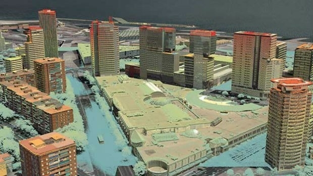
27th September 2016
eeGeo Partners With AMP for Interactive Real Estate 3D Mapping26th September 2016
Hexagon Safety & Infrastructure Acquires GISquadrat22nd September 2016
Orbit GT CEO to talk on Worldwide Business with kathy ireland®21st September 2016
Fugro Focuses On Innovation At Wind Energy, Hamburg21st September 2016
Arizona Department of Transport chooses 1Spatial Technology19th September 2016
Arup and KPF front panel at British Information Modelling Event18th September 2016
Xsens launches online support platform 'BASE'17th September 2016
Sam Shoemaker brings strategic mine planning expertise to Maptek16th September 2016
Watford Derailment Strengthens Mobile Mapping Argument15th September 2016
Bentley Institute and Rutgers University Collaboration14th September 2016
Orbit GT and AAM Group, Australia, join forces13th September 2016
Bentley Systems announces OpenRoads ConceptStation13th September 2016
Bentley Systems announces OpenRoads Navigator9th September 2016
Bentley Systems announces the availability of ConstructSim9th September 2016
PDF3D Releases Microsoft OFFICE Enhancements with 3D Plugins8th September 2016
Hexagon Safety & Infrastructure Listed on G-Cloud 8 Framework7th September 2016
StreetMapper helps to power growth for AAM in India7th September 2016
Bluesky Publishes First Online 3D Maps of Isle of Man6th September 2016
Orbit GT launches QGIS plugin for Mobile Mapping.31st August 2016
AssetWise APM Opens SAP Enterprise Asset Management Data31st August 2016
Forrester designates Pitney Bowes as Geospatial Leader30th August 2016
Cardno Provides Services to U.S. Northwest Law Enforcement Agencies30th August 2016
Earthquake in Myanmar Damage 171 Ancient Buddhist Pagodas30th August 2016
OGC proposed work item for 3D Tiles as a Community Standard29th August 2016
VisionMap A3 Edge Innovates Precision Agriculture in North Dakota29th August 2016
CGG Launches TopSeis - The Solution for Imaging Shallow Reservoirs24th August 2016
Pitram implemented at one of the largest mines in Mongolia24th August 2016
Patent Awarded for 3D Terrain Maps in PDF18th August 2016
Laser scan coordinate system tools released in Maptek I-Site Studio16th August 2016
Introducing Improved Mine Scheduling Software15th August 2016
4DMapper; the secret behind sharing geodata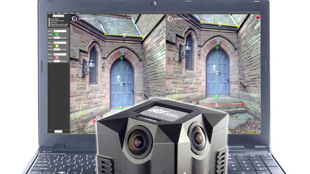
11th August 2016
New SphereVision 360 Imaging Software Integrates iSTAR Measurement Module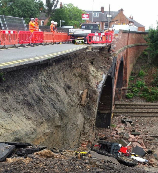
10th August 2016
Barrow Upon Soar Rail Closure Prompts Monitoring Calls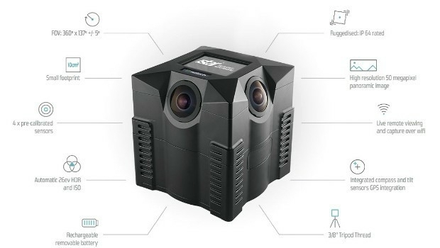
10th August 2016
iSTAR 360 degree Measurement Module integrated by imaging companies10th August 2016
MICROMINE's latest feature on Implicit Modelling