

Content

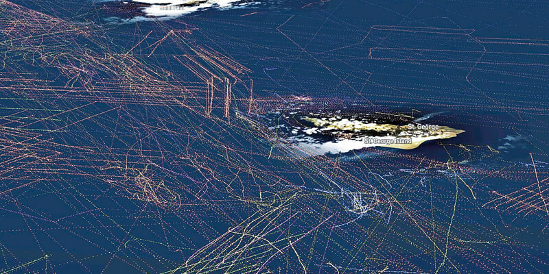
How a maritime collision avoidance system is making an impact
29th October 2020
How a maritime collision avoidance system is making an impact


Simplifying location data access and processing
29th October 2020
Simplifying location data access and processing

Fugro’s Major Upgrade To Lads Technology Improves Hydrographic Data Collection In Australia And Pacific Region
29th October 2020
Fugro’s Major Upgrade To Lads Technology Improves Hydrographic Data Collection In Australia And Pacific Region
Japanese City Using GIS on iPads for Field Survey
29th October 2020
Japanese City Using GIS on iPads for Field Survey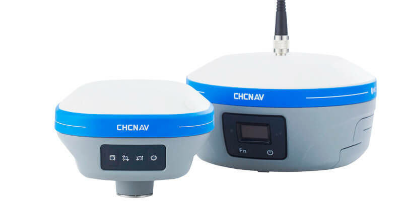
CHC Navigation introduces the i73 GNSS and iBase GNSS receivers
29th October 2020
CHC Navigation introduces the i73 GNSS and iBase GNSS receivers
Researchers Innovate Using Lidar And Hyper-Spectral Scanners To Document And Help Restore Burn Areas
29th October 2020
Researchers Innovate Using Lidar And Hyper-Spectral Scanners To Document And Help Restore Burn Areas
SimActive Develops New Workflow for Faster Processing of Large Projects
29th October 2020
SimActive Develops New Workflow for Faster Processing of Large Projects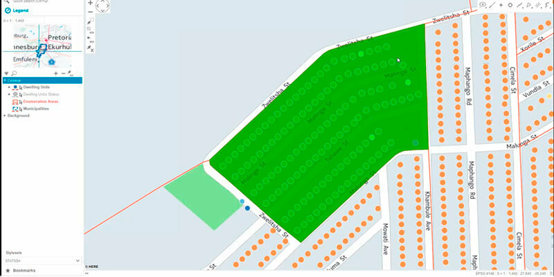
Hexagon Unveils HxGN Smart Census 2020 for Enhanced Citizen Data Collection
29th October 2020
Hexagon Unveils HxGN Smart Census 2020 for Enhanced Citizen Data Collection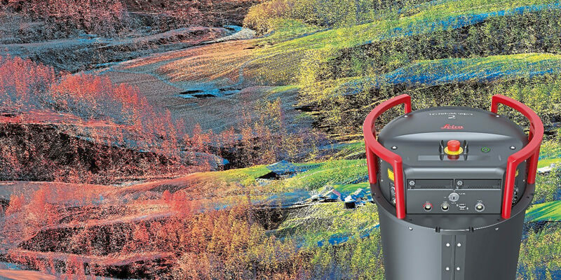
Leica Geosystems continues airborne hybrid road map with latest modular sensor offering
29th October 2020
Leica Geosystems continues airborne hybrid road map with latest modular sensor offering
Riegl presents new products at Intergeo 2020
29th October 2020
Riegl presents new products at Intergeo 2020
Septentrio unveils AsteRx-m3, the next generation of high-precision GNSS receivers
29th October 2020
Septentrio unveils AsteRx-m3, the next generation of high-precision GNSS receivers
European Association of Aerial Surveying Industries Appoints Secretary-General
29th October 2020
European Association of Aerial Surveying Industries Appoints Secretary-General


thinkWhere Appoints Louise Barnes as Chief Commercial Officer
29th October 2020
thinkWhere Appoints Louise Barnes as Chief Commercial Officer
KebNi Special Advisor To Spearhead Move Into $5US Billion LEO Satellite Market
29th October 2020
KebNi Special Advisor To Spearhead Move Into $5US Billion LEO Satellite Market
Satellite Imagery Specialist 4 Earth Intelligence Appoints Managing Director
29th October 2020
Satellite Imagery Specialist 4 Earth Intelligence Appoints Managing Director
TDI-Brooks International Completes EBS Program Offshore Ivory Coast
29th October 2020
TDI-Brooks International Completes EBS Program Offshore Ivory Coast
Inmarsat and Cobham SATCOM enable Maldives fisheries sustainability with Fleet One
29th October 2020
Inmarsat and Cobham SATCOM enable Maldives fisheries sustainability with Fleet One
Alteia accelerates the deployment of its Enterprise AI Solutions and announces global alliances with GE Digital and Microsoft
29th October 2020
Alteia accelerates the deployment of its Enterprise AI Solutions and announces global alliances with GE Digital and Microsoft
Trimble and Boston Dynamics Announce Strategic Alliance
29th October 2020
Trimble and Boston Dynamics Announce Strategic Alliance
UP42 Partners with Hexagon To Offer HxGN Content Program Aerial Imagery on Geospatial Marketplace
29th October 2020
UP42 Partners with Hexagon To Offer HxGN Content Program Aerial Imagery on Geospatial Marketplace
Sapcorda Expands Safety-Critical GNSS Augmentation Services for Automotive with powerful L-band Satellite Links
29th October 2020
Sapcorda Expands Safety-Critical GNSS Augmentation Services for Automotive with powerful L-band Satellite Links
Tallysman Introduces a line of embedded Full-band and Triple-band VeroStar GNSS Antennas
29th October 2020
Tallysman Introduces a line of embedded Full-band and Triple-band VeroStar GNSS Antennas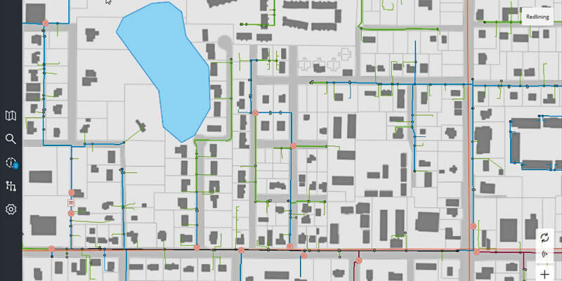
Schneider Electric Releases ArcFM Mobile 11.2.1
29th October 2020
Schneider Electric Releases ArcFM Mobile 11.2.1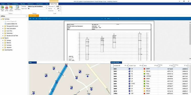
Bentley Systems Announces Availability of OpenGround Cloud
29th October 2020
Bentley Systems Announces Availability of OpenGround Cloud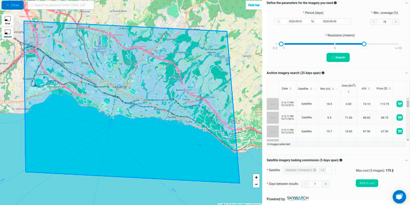
SkyWatch and Picterra Join Forces to Make Geospatial Insights Available to All
29th October 2020
SkyWatch and Picterra Join Forces to Make Geospatial Insights Available to All
EuroGeographics pledges support for UN-GGIM focus on authoritative geospatial data
29th October 2020
EuroGeographics pledges support for UN-GGIM focus on authoritative geospatial data
OGC and ODA Announce Strategic Partnership
29th October 2020
OGC and ODA Announce Strategic Partnership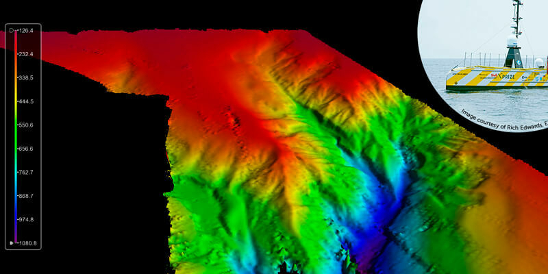
Teledyne CARIS AI software onboard successful UTAS USV mission
29th October 2020
Teledyne CARIS AI software onboard successful UTAS USV mission
Novara GeoSolutions Awarded the Esri Release Ready Specialty Designation
29th October 2020
Novara GeoSolutions Awarded the Esri Release Ready Specialty Designation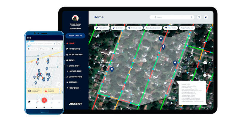
AiDash Taps UP42 Earth Observation Platform to Create Vegetation Management System for Electric Utilities
29th October 2020
AiDash Taps UP42 Earth Observation Platform to Create Vegetation Management System for Electric Utilities
Golden Software Improves Surfer File Handling for Faster Mapping
29th October 2020
Golden Software Improves Surfer File Handling for Faster Mapping
exactEarth Announces Successful Launch of the ESAIL Microsatellite
29th October 2020
exactEarth Announces Successful Launch of the ESAIL Microsatellite
COVID-19: e-GEOS (Telespazio/ASI) will develop a solution to monitor the economic recovery
29th October 2020
COVID-19: e-GEOS (Telespazio/ASI) will develop a solution to monitor the economic recovery
Globalstar Satellite IoT Device Deployments for Relief Agencies Double in 12 months for Specialist Reseller Traksat
29th October 2020
Globalstar Satellite IoT Device Deployments for Relief Agencies Double in 12 months for Specialist Reseller Traksat
RoadCloud to offer premium road data on the HERE Marketplace
29th October 2020
RoadCloud to offer premium road data on the HERE Marketplace
Virtual Surveyor Offers Enhanced Functionality in Free Version of Drone Surveying Software
29th October 2020
Virtual Surveyor Offers Enhanced Functionality in Free Version of Drone Surveying Software
East View Geospatial Partners with AllSource Analysis
29th October 2020
East View Geospatial Partners with AllSource Analysis
iXblue builds capacity for simultaneous operations on either side of the Tasman
29th October 2020
iXblue builds capacity for simultaneous operations on either side of the Tasman
CGG GeoSoftware Launches Interactive Well Path Planning Technology
29th October 2020
CGG GeoSoftware Launches Interactive Well Path Planning Technology
Creaform announces new and complete R-Series suite of automated dimensional quality control solutions
29th October 2020
Creaform announces new and complete R-Series suite of automated dimensional quality control solutions
Teledyne DALSA releases powerful suite of image processing and artificial intelligence software
29th October 2020
Teledyne DALSA releases powerful suite of image processing and artificial intelligence software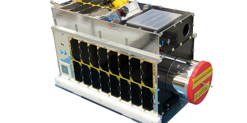
Space Flight Laboratory Announces Launch of Atmospheric Monitoring and Earth Observation Microsatellites
29th October 2020
Space Flight Laboratory Announces Launch of Atmospheric Monitoring and Earth Observation Microsatellites
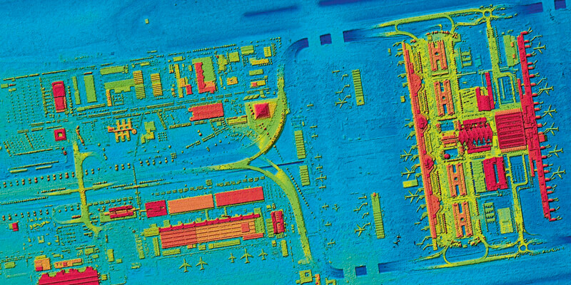
First high-resolution, homogeneous Digital Surface Model (DSM) for Germany
29th October 2020
First high-resolution, homogeneous Digital Surface Model (DSM) for Germany
GMV announces the merger of its UK Company and NSL
29th October 2020
GMV announces the merger of its UK Company and NSL
Schneider Digital’s 3D PluraView stereo monitor
29th October 2020
Schneider Digital’s 3D PluraView stereo monitor
Esri Acquires nFrames to Enhance Its 3D Capabilities
29th October 2020
Esri Acquires nFrames to Enhance Its 3D Capabilities
senseFly drones help monitor Lake Winnipeg ice hazards
29th October 2020
senseFly drones help monitor Lake Winnipeg ice hazardsArchive