Share
Passive microwave soundings combined with land- and satellite-based observation and measurement data can create a full volumetric view of weather from the Earth’s surface to the troposphere. David Gallaher looks at the potentially life-saving applications
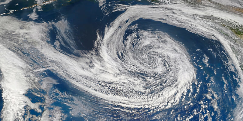
Though it may not be considered true radar, passive microwave radiometers can collect data as both imagers and sounders, providing excellent observations into atmospheric conditions and propensities. A constellation of passive microwave satellites could provide timely data as frequently as every 15 minutes for any point on the Earth. This information can be easily incorporated into a GIS to create a near real-time view of any location. The resulting observed microwave data can be used to create high-definition 3D radar-like images of weather structures within clouds.
The nature of microwave radiation is well understood, allowing for highly accurate measurement of precipitation and density as well as temperature throughout an air column. When combined with other land- and satellite-based observation and measurement data, the information collected by microwave radiometers aboard satellites completes the full volumetric view of weather from the surface to the troposphere.
The data from these observations can also be used to pinpoint conditions and inform decision-making in navigation across areas of the globe not covered by traditional radar systems. The timeliness of this data is critical – worldwide, on average, two large ships sink or otherwise go missing every week, usually with a loss of all hands, according to Wolfgang Rosenthal, head of MaxWave, a project sponsored by the European Space Agency to better understand large wave and storm incidents at sea.
The El Faro incident
On 29 September 2015, the El Faro left Jacksonville FL in the US for San Juan, Puerto Rico, carrying a cargo of 391 shipping containers, some 294 trailers and cars, and a crew of 33 people. The ship’s captain took the vessel a reasonably safe distance away from a newly formed tropical storm.
At the time of departure, Hurricane Joaquin was still a tropical storm, but meteorologists forecast that it would likely become a hurricane in two days. Less than 30 hours after the ship had departed Jacksonville, the US Coast Guard received a satellite notification that the vessel had lost propulsion and was taking on water. It sank shortly afterward as it had sailed directly into the eyewall of the hurricane.
In investigative reports, the Coast Guard and National Transportation Safety Board noted that the captain had relied on outdated weather information from a commercial service, which they surmised was a significant factor in the sinking.
For navigation, ocean-going vessels rely on what can be seen with onboard radar, typically allowing a view between the current location and the horizon. However, since the basic principle of radar is the measurement of radio waves reflected from the surface of the incoming storm, surface-level radar cannot penetrate the full extent of a storm, limiting information about the size or potential duration of a system.
Route planning may also be influenced by weather models, which are typically produced from available satellite data. Unfortunately, the temporal frequency of observations –ranging from three hours to as much as three days – available from the nine operational government-operated satellites is insufficient for real-time decision-making. Visible and infrared satellites offer a much better temporal frequency of data collection, but they are limited to visualisation of cloud tops, and cannot see the location of storms and precipitation in clouds.
In this situation, navigation is nearly as much art as science. Extending the radar view beyond the horizon with observed, rather than modelled, weather information and tying that information directly to known geographic coordinates can improve both efficiency and safety. Interlocking observed data – satellite and onboard – with geopositioning information solidifies the reliability and utility of the information, and empowers data-driven navigational decisions.
Technology advances
Advances in instrument miniaturisation and the growth of the cubesat industry have combined to improve the temporal specificity of microwave observations. Operating in low earth orbit (LEO), these relatively inexpensive satellites can gather and deliver data gridded and geographically locked to earth coordinates. Operating in LEO enables higher resolution images and the combined improved cost factors make operation of a constellation of satellites affordable.
With as few as 12 cubesats equipped with microwave radiometers, observation revisits for any point on earth will be below one hour. This frequency of observation will produce datasets that can integrate with geolocation information to create a new active GIS dataset with direct commercial applications.
Passive microwave sounding is unquestionably the most effective technology for detecting atmospheric conditions from the surface upward, regardless of cloud cover. The ability to observe weather structures inside and below clouds offers numerous advantages over visual, or even infrared, technologies. Only microwave data can measure the amount and density of precipitation within a system, helping to better understand the severity of a front and its potential to disrupt commerce or do damage.
With sub one-hour observations, storms could be tracked more closely, and appropriate decisions could be taken with more confidence. The formation and evolution of storms over oceans is not easily observed through traditional methods, yet the impacts can be significant. Overlaying the microwave data from the IOD-1 GEMS satellite – the first LEO satellite in the Orbital Micro Systems Global Environmental Monitoring System constellation – would provide an easy method to determine near real-time risks in applications such as planning transoceanic shipping routes, delivering valuable insights for avoiding adverse weather, and maximizing safety, efficiency, and profitability.
New applications
The potential use cases for geo-gridded information over the oceans will grow with the availability of new microwave-observed data at densities that have not existed before. Cubesats and miniaturisation are now making the availability of this data both practical and possible. This data, combined with other geospatial datasets, has benefits in aviation, agriculture, risk management, disaster planning, flood monitoring, and a host of other applications.
Looking beyond the horizon, these robust datasets will enable better real-time awareness for a number of scenarios, such as flexible route planning, all of which will lead to better outcomes for safety, performance and economics.
David Gallaher is chief operating officer of Orbital Micro Systems (www.orbitalmicro.com)


