Share
Charles University and UpVision have been testing low-altitude UAV laser scanning for detailed mapping of hard-to-reach areas in the Czech Republic, including dams and cirque glaciers. Jakub Karus reports on the results
High-quality laser scanners are now available that can be placed on commercially available UAVs to create point clouds for digital terrain models (DTMs). The great potential of laser scanning from a UAV is it can scan objects such as rocks, steep slopes, and inaccessible or dangerous locations where classical ground laser scanning cannot be used or vegetation coverage makes it difficult to create an accurate DTM using classical mapping from a UAV and photogrammetry. Charles University and UpVision in the Czech Republic have been testing UAVs in such environments and the results so far have been promising.
We used the DJI Matrice 600 Pro UAV, as it has excellent flight characteristics, a load capacity of up to 6kg and a flight time of up to 16 minutes in good conditions. It can also be fitted with various sensors, with regard only to size, weight and power supply.
The miniVUX-1UAV laser scanner weighs 1.6 kg and can be hung directly under a UAV without the use of a gimbal. It has a 360° field of view, can take 100,000 measurements per second and has a standard operating height of up to 100m above the ground.
To obtain the most accurate and detailed DTM possible, it is necessary to fly a UAV relatively close to the location or object to be mapped, where the density can be quickly calculated. If a high cloud density is needed, it is effective to execute the flight plan in lines with overlaps, set depending on the flight height and scanner range. To increase the density of the point cloud and to best cover the terrain, flying lines in two directions perpendicular to each other is the most effective option.
When mapping poorly accessible or dangerous locations, it is not possible to rely on a pre-scheduled flight plan in low altitude or close to the vegetation, especially trees, as you won’t have an exact altitude model of the location. You will therefore need to fly the UAV in lines manually. To do this, we found adding a first-person viewpoint camera to the UAV increases safety, as you can check in real time whether the UAV is moving at a safe distance above terrain or vegetation.
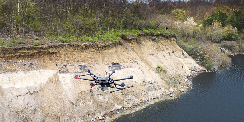
Give a dam
We tested UAV-mounted laser-scanning in various experimental localities in the Czech Republic. One of these was part of the 3.3km bank of the Nechranice dam, which is the longest rock-fill dam in Central Europe, with parts of the bank formed by perpendicular slopes up to 15m high that drop down into water.
When creating a detailed digital model of these walls, it is necessary to focus on where the laser scanning will be repeated and compared, avoiding areas that have the greatest risk of landslides or present some other safety risks. These walls are often covered with various roots and remains of vegetation, so laser scanning is the best way to obtain the best digital models of these banks. Since the walls are between the water surface and the terrain above, it is impossible to use terrestrial laser scanning from the shore; the only other option would be to scan the walls directly from the water surface, which would be very complicated in terms of both acquiring and aligning data.
However, laser scanning was very easy from the UAV at the bank elevation at a distance of about 20m from the bank and above the water surface, providing a high point cloud density from which it was possible to create a very accurate digital model with a density of several hundred points per square metre. Laser scanning of the shoreline for about 300m required two flights lasting about 40 minutes in total, without any risk of movement at the edge of the shore or directly on the water surface.
Cirque without soleil
We also tested the laser scanner by mapping a part of the Úpská pit, which is a cirque glacier directly below the highest mountain in the Czech Republic – Sněžka, near the Polish border in the Krkonoše National Park. The valley walls are up to 600m high and are dangerous to move around, especially for mapping. They are also very steep, slippery and covered with vegetation.
To obtain an accurate DTM, it is necessary to use laser scanning, which is only possible in such difficult terrain from a UAV. Even flying with a UAV is challenging, because there are different air swirls in the cirque, and you must choose the most suitable climatic conditions with the least wind possible. The upper boundary of the cirque can be reached on foot with a UAV, from where you can see the main part of the cirque valley.
The UAV required manual piloting in such a sharp abyss, again in rows perpendicular to each other – first in one direction down and then crossing lines up to the edge of the cirque. The UAV flew below the top edge of the cirque under constant control by the pilot, using the onboard camera to keep it at least 20m from the terrain, as the view of the descending UAV against the terrain was very distorted. In this way, the UAV flew more than 120m below the pilot’s position on the edge of the cirque and thus moved at a high minus altitude against the take-off point. By crossing the flight lines, which alternated two laser scanning positions simultaneously, a high density of scanned points was achieved – up to 1,000 points per square metre.
Great potential
It can be clearly seen from these examples that the combination of a UAV and a laser scanner has a high application potential for highly detailed, accurate and efficient mapping of hard-to-reach locations and objects without any of the unnecessary risks associated with movement in such environments. In the future, greater use of UAVs with LiDAR can be expected in such areas.
Jakub Karas is a UAV manager and consultant, and the co-owner of Upvision (www.upvision.cz)


