Share
In 2002, the Automatic Identification System for vessel tracking and collision avoidance became operational. The data logged is now affecting many industries outside the maritime sector. Bart Adams explains hoW
We live in a world that is becoming increasingly more digital and connected. The list of assets being tracked continues to grow – vehicles, vessels, people. The Internet of Things (IoT) is entering industries ranging from logistics to manufacturing, as well as our own (smart) homes.
One sector that has been slow to innovate is nevertheless now revolutionising many other industries, helping in everything from battling illegal fishing to forecasting the financial markets.
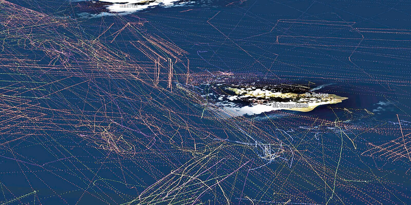
The Automatic Identification System (AIS) has been available to the maritime sector since 2002. Initially, it was developed to assist with collision avoidance and detection using GPS, together with wireless communication technology, by communicating the location and status of a vessel to other nearby vessels, enabling captains to better and more safely navigate waters and ports. The vessels surrounding a ship and their courses are visualised on a screen, possibly on top of nautical charts, for the captain and crew to obtain situational awareness.
AIS messages are picked up by other vessels and receivers at the shore to complement radar video as the source for so-called Vessel Traffic Services (VTS). However, besides local collision avoidance and vessel traffic services, the real value from AIS comes with the advent of global satellite-enabled systems. Companies such as Spire Global use nanosats to pick up the AIS messages and relay them to the Earth’s surface where the data is collected, cleaned up and stored in the cloud. APIs are then provided to query and analyse the data for use by data scientists, analysts or software providers to include a real-time and historical data source.
This is where the picture started changing. We now have a continuous and global view of how vessels move about the seven seas and inland waters. Tanker operators can now track their fleet worldwide; a terminal operator can use global AIS data to predict when and how many tankers will arrive in the coming days and weeks or form a competitive perspective. Tanker operators can monitor their competition, gaining insight into where and how they operate.
However, there are challenges in using AIS data. For example, even though turning off the AIS transponder or logging incorrect values in the AIS messages is illegal according to the International Maritime Organization, ships do ‘go dark’ or mess with the content of the messages to remain under the radar. These “bad data” cases are often the basis for analytics and insight generation in use cases such as detection of illegal fishing. However, the fact that data is missing or incorrect is usually a challenge that needs to be considered by analysts and software tools. When data is bad or missing, the importance of visualising the data and not blindly relying on its correctness, is of key importance.
In all these cases, it’s not just the current location of the vessels that are required, but the vast amounts of historical data. With hundreds of thousands of vessels around the world, this data is really Big Data – not quite the data that is easily handled by Excel or business intelligence tools.
Luckily, there are several other options, including the platform that we built at xyzt.ai. We have created a Big Data location analytics SaaS solution that is capable of handling the massive amounts of AIS data needed to investigate large regions and long periods of time. We engineered our platform from the ground up, focusing on efficient data structures and algorithms for handling space-time location records, such as AIS data. We compress the data as low as a dozen bytes per record, exploiting coherency and redundancy in the data, allowing us to handle billions of location records, without the need for an expensive distributed server farm or high-end GPU nodes, making it cost-effective and easy to deploy.
When a GPU algorithm needs to visualise a heat map of vessel traffic, it goes through each vessel trajectory and paints it on top of the others, accumulating the colours leading to the heatmap – you can compare this to a child wanting to count the marbles in a bag of marbles by taking them out and counting each marble one by one. Our algorithm uses a different approach; instead of counting the marbles one by one, we take out just one marble, weigh it, weigh the whole bag and then derive the number of marbles. This enables us to scale to all new levels – and apply AIS data outside the maritime sector.
A wide reach
We and Spire Global have already shown that AIS data can be used to analyse the impact of COVID-19 on large passenger travel, looking at both global and local trends. From the AIS data alone, it is clear that the cruise ship industry is severely affected in regions ranging from the Port of Cozumel in Mexico to the Tasman Sea in Australia.
However, the application of AIS data and insight generation reaches much further than just the maritime industry. Probably, the most significant future impact will be in other sectors.
Industry leaders in the intelligence domain, such as Kpler, ClipperData and IHS Markit, use AIS data as one of the sources to analyse commodity inventories, flows and freight, with specialisations ranging from tracking LNG, LPG, crude oil, and dry bulk such as coal and iron ore.
Researchers at the International Monetary Fund have even shown that AIS data can be used for nowcasting trade activity in real-time and quickly detecting the turning points in the economic cycle. It provides a faster way to look at our economy to see the effects of geopolitical events and better predict recovery. They propose new, more timely statistics that measure trade flow to complement existing data sources and economic indicators.
So, who knows what insights people will be able to glean from AIS data as a result of our Big Data platform – and in what industries?
Bart Adams is CTO and founder of xyzt.ai (https://xyzt.ai)


