Share
The COVID-19 pandemic resulted in an urgent requirement for extra hospital capacity around the world. Geospatial technology played an important role in this expansion, as David Fowkes explains
Worldwide, in the past few months, we have seen a global effort to expand hospital capacity to deal with the outbreak of COVID-19. This added urgency, combined with the importance of public safety, has made it a major challenge for public health bodies to assess sites’ suitability for temporary or new hospitals. Teams on the ground need to be able to complete assessments quickly and safely, so accessibility and speed are more important than ever.
Traditionally, public health officials relied on hiring surveying experts to operate a static scanner, taking time to set up and then map out the site. But social distancing and travel restrictions have added obstacles to surveying projects.
A handheld mobile mapping device that uses SLAM technology therefore comes into its own in these situations, as its ‘scan and go’ capabilities mean it does not require GPS and can be used without the need for training.
To scan one hospital site, the GeoSLAM team worked with Microgeo operator Ventimiglia Mattia for its client, Tecnoin Naples, which was tasked with scanning a hospital building near Naples to assess its structural integrity, as well as create floor plans and building measurements. The building, with five storeys above ground and two basement levels, was showing signs of years of wear and tear. Maintenance teams were particularly concerned with potential movement of columns which were central to the building’s structural integrity.
Emergency assistance
A project to assess damage to the building had already begun using terrestrial scanners. Teams were already weeks into a project painstakingly moving static scanners around the busy hospital building.
With Tecnoin seeking a precise scan delivered at speed, Ivona Hubova, GeoSLAM’s senior applications engineer, travelled to Italy to provide support. GeoSLAM’s ZEB-HORIZON was chosen as the scanning tool, as it can capture as many as 300,000 points per second at a range of up to 100m. Before starting the scan, a walkthrough of the building had to be completed to find the best position to start, as well as the best route to complete a circular loop so that the start and finish environments could be accurately matched together.
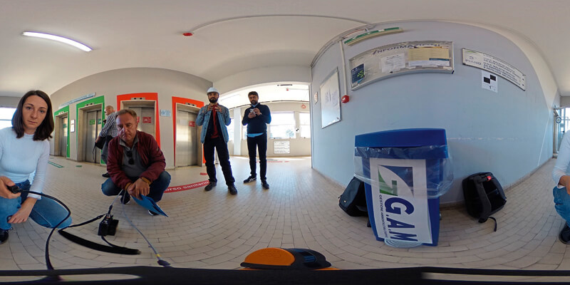
Hubova worked with a Tecnoin engineer, who assisted with directions and opening doors, as she scanned all seven floors of the hospital on foot in under an hour to assess the position of the structural columns. Using the ZEB-PANO accessory, which combines 360° panoramic photography with SLAM data capture, they also captured vital additional imagery of the old building.
In some cases, the troublesome columns were built into walls, making it challenging to get a detailed view of the structure. The imagery was particularly useful to give an enhanced insight into the building and ensure it remained safe for use.
A4 checkerboards had already been installed by the terrestrial scanning team in areas with good visibility, such as door frames, throughout the main staircase, in hallways and by lifts, to provide reference points. A simple reference plate, which allows the ZEB-HORIZON scanner to be held stationary on a reference point for five seconds to automatically reference coordinates, enabled the team to record the location of the checkerboards, which avoided considerable manual work creating control points when processing the data.
An additional project to assess the two floors of office space used by doctors and administration staff was completed on the same day. In a building which is in use at all hours, this might be a complex task with a static scanner. But all offices were scanned in under an hour, with staff only interrupted for a minute or two for the scan to take place.
Processing the data
In total, the team carried out five different scans during the day. The reference points were used as control points to help merge the scans and georeference the data, enabling the team to create accurate 3D models for analysis. The client’s surveyors were able to identify key features of the building for the models, including its structural safety, the number and location of power outlets for ventilators or other machines, as well as how space could be used for additional beds.
To closely investigate the data, Hubova used GeoSLAM’s Hub software to create interactive point clouds, exporting the scan data onto the Hub solution and then importing to its Draw module to add the associated imagery at the click of a button.
A key consideration was to be able to measure the angles of the columns in the hospital. Ivona used Draw to analyse the data and export it to AutoCAD, to compare the results against existing models and the data from terrestrial scanners.
After spending half a day completing the various scans, the team processed the data and merged the point clouds with the imagery to create an interactive 360° panoramic view of the inside of the building and its offices, ready for a meeting with the client the next day.
Ultimately, the team was able to present an accurate assessment of the building in one day with minimal disruption to the hospital’s day-to-day activity. The scan’s results were within 2mm of a terrestrial scanner’s – a highly impressive accuracy when you consider the difference in the time needed.
Prioritising worker safety
In these challenging circumstances, time is obviously hugely important, but staff safety is of far greater significance. Using a terrestrial scanner, setting up the device every one or two metres, it could take a surveyor days or even weeks to scan a substantial building, potentially exposing them and the people they encounter to infection.
In comparison, a handheld scanner offers rapid surveying, reducing data collection to minutes or hours and enabling one operator to walk through the building at a consistent pace and observe social distancing guidance.
There is no doubt that the wider health of our communities is the ultimate priority. We all hope that these new or repurposed hospitals are used as little as possible over the coming weeks and months. But, if they are, SLAM could have a huge role to play in helping officials to quickly and easily check the safety and viability of each venue.
David Fowkes is sales director at GeoSLAM (www.geoslam.com)


