Share
With the recent catastrophe in Beirut fresh in mind, what further disasters-in-the-making can we prevent or mitigate? Terri Freemantle speaks to Murray Purves at Riskaware to discuss another potentially volatile situation and how satellite data and mathematical modelling is being used to assess the risk
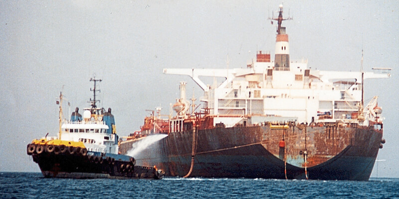
In a lonely area of the Red Sea, off Yemen’s West Coast, rests an unassuming oil tanker which holds a dirty secret. This tanker - the FSO SAFER - is an abandoned floating oil terminal with a cargo of over one million barrels of oil.
Since the outbreak of the Yemeni civil war in 2015, the SAFER has fallen into a state of disrepair, and there are concerns in the international community that the vessel is at risk of releasing its cargo into the environment, either from an oil leak from the vessel itself or from an onboard explosion/fire, leading to the release of pollutants. It represents a ticking timebomb that would have a catastrophic economic and environmental impact on vulnerable ecosystems and local populations, many of whom rely on the waters of the Red Sea for their livelihoods.
But how can the relevant authorities assess the potential impacts of a release from the vessel? I am speaking with Murray Purves, Senior Consultant at Riskaware, to find out how data and technology can help.
Murray, how did Riskaware become involved with this work?
Riskaware was contracted by the Satellite Applications Catapult to apply its incident modelling expertise to predict the potential impacts of a release of air and water-borne pollution from the SAFER. This would better inform the international discussion surrounding the fate of the tanker and the risks it poses to the region. We undertook this work on behalf of the UK’s Department for International Development (DFID).
Can you talk me through the mathematical modelling undertaken and what were the biggest challenges of this analysis?
The Riskaware team brought together its capabilities in both atmospheric and oil spill dispersion modelling to bear on this urgent problem. We used NOAA’s HYSPLIT model to undertake the atmospheric dispersion modelling portion of the study, with our own MarineAware model used for the oil spill modelling.
Because of the uncertainty concerning the state of the SAFER, it was difficult to estimate exactly what a potential release may look like - both in terms of the amount of pollution, and the way in which it would be released (e.g. spilled into the water, or burned causing air pollution).
In the absence of accurate and up-to-date information regarding the condition of the vessel, we took a ‘worst-case’ approach: initialising the models with a source term representing the rapid release of all the vessel’s cargo, either into the water as for an oil spill model) or into the atmosphere.
The fact that the SAFER is at risk of releasing a large amount of pollution is a given. However, we don’t know when a release may occur. Additionally, weather and tidal conditions in the region are highly seasonal, with changing prevailing winds and currents. This means that a release occurring in July, for example, might travel in a very different direction to one occurring in January.
Unlike the model source term, there is no obvious ‘worst case’ set of weather conditions we can use; instead, we took a statistical approach. We took three years of historical data and separated it into four roughly seasonal periods. For each of these periods, hundreds of model runs were carried out, with each run utilising data corresponding to a randomly sampled release time within this period.
The outputs from these model runs were then processed to generate combined ‘probability of exceedance’ plots. Rather than showing the output from a single prediction of oil/air pollution dispersion from a release, these plots represent the risk of certain areas experiencing heavy contamination should a ‘worst-case’ release occur.
I think we can safely say this analysis is a clear example of using data to drive impact, can you explain how this work has been actioned at the practical policy level?
The results of these modelling campaigns have been used by DFID to contribute to the international conversation surrounding the vessel, with the results being disseminated internationally at the highest levels. We consider ourselves very privileged to have been asked to work on this project. We aim to apply our experience with incident modelling in a way that can hopefully help bring about a constructive outcome in a complex situation, by providing actionable intelligence that can be used to affect positive change.
Murray, thanks for sharing your insight on this unique analysis.
This project was funded by the UK’s Department for International Development. If you would like to find out more about Riskaware, please visit https://www.riskaware.co.uk/


