Share
With more than a third of the world’s tailings dams at high risk of causing catastrophic damage to nearby communities should they fail, Delia Di Filippantonio relates how satellite-derived information can help make them safer and more sustainable
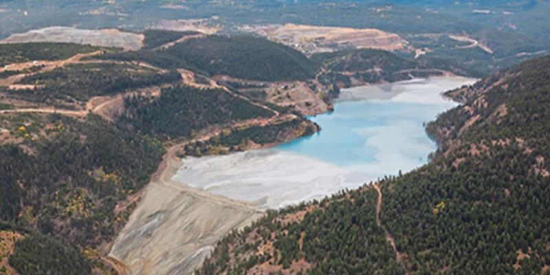
Tailings Storage Facilities (TSF) are dynamic structures that store the waste by-products (tailings) of mining operations for the entirety of the mine lifecycle.
The safety and stability of these structures is a key challenge both for mining companies and the broader ecosystem including investors, government authorities and local communities.
The Satellite Applications Catapult1 has been investigating the role that geospatial data can play within this topic as part of a BEIS-funded pilot project within the Investor Mining and Tailings Safety Initiative.2 This initiative was set up by the Church of England Pensions Board and the Swedish National Pension Funds’ Council on Ethics to address TSF safety concerns globally.
The Tailings Sense platform was created as a demonstrator showcasing satellite-derived information including TSF displacement values, presence of seepage, identification of previously unknown TSF and impact modelling.
Key to the usability of satellite-derived data is the translation of complex outputs in a format, such as a chart showing a trend in displacement behaviour, that a mining engineer can easily analyse to understand implications for the TSF safety.
In parallel to the technical demonstration, the project team conducted user research to explore geospatial data use cases for a broader cohort of stakeholders, with an initial focus on the finance community.
Risky business
Through their investments in mining companies, financial institutions such as insurers, banks, asset managers and asset owners are exposed to a range of financial and reputational risks associated with TSF. However, the specific data challenges they face are different in scope and timeframe from those of mining companies.
Financial institutions usually work with hundreds or thousands of companies, either directly or through investment portfolios. Their primary sources of information are mining company disclosures and data from third-party providers. They use aggregated data products such as risk scores to prioritise interventions across their portfolio.
Currently, specific TSF risk parameters are not included in these aggregated data products. There is thus an opportunity for risk information such as SAR-derived displacement values to be incorporated in this format to enrich these scores.
Modelling the consequences
Geospatial data can also directly support analysts researching prioritised, higher-risk TSF. For instance, satellite imagery can provide great detail on critical infrastructure location, previously unidentified TSF or urbanisation changes in the area to help qualify and quantify risk. Modelling the consequences of failure can offer investors a valuable insight in shaping questions for a mining company.
The finance community is only one of many stakeholders that can benefit from better data on TSF. There is a real opportunity to use geospatial information, accurately “translated”, to bridge the communication and knowledge gap that exists on this topic between local communities, mining companies, investors, and government authorities.
1. https://sa.catapult.org.uk/
2. https://www.churchofengland.org/investor-mining-tailings-safety-initiative


