Share
Arnaud Denisot is a young IT engineer who decided to change his life.
Four years ago, he left his job at La Défense, the Paris-region version of Silicon Valley, and re-established himself with a drone services company headquartered in the seaside town of Sanur, Bali. The new company, Bali Drone Production, gathered steam as a result of its drone and photogrammetry services, but things really took off when Denisot bought his first LiDAR last December, launching with it a new specialized mapping branch of the company called MSDI
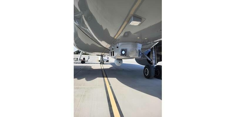
“Thanks to the Vx-15,” he says, “we can now be a major player in UAV LiDAR survey services in Indonesia, provide accurate data in correlation with the environmental constraints we encounter here, and intervene quickly on urgent projects.” Prior to acquiring the YellowScan Vx-15, Bali Drone Production would fly their Phantom 4Pro or Mavic 2 drones and carry out 3D mapping with ground control points (GCPs) and real time kinematic (RTK) photogrammetry systems. Clearly such equipment would prove insufficient.
The major challenge Denisot faced was one that many surveyors encounter in canopy-heavy Indonesia. “The dense vegetation here and Indonesia’s vast terrain is often rugged and inaccessible. Our technical means and equipment didn’t allow me to provide quality data for my clients,” he says. “I needed to offer new top-of-the-range services to my customers, to extend my range of services and to make my company grow in the industrial field. LiDAR therefore quickly became an obvious choice.”Flying a light-weight drone-mounted LiDAR system that can easily penetrate canopy for efficient 3D mapping enabled Denisot to land his first big job in April, doing a 1,100 hectare survey for a palm oil company. As he points out, “We needed a system that could penetrate the canopy, portable and easy to use to limit the time on the ground and not be cumbersome. Because Indonesia is composed of multiple islands, we are regularly required to take a plane, so the equipment must be compact and respect the recommendations of the airline companies. Finally, we needed a versatile system, able to meet all kinds of demands, even the most demanding as in the field of civil engineering.”
The MSDI job order came in at the 11th-hour, with Denisot having to pick up where another mapping company had failed to complete its mission as a result of a technical mishap. When the competing company could no longer operate their equipment, Arnaud had to come up with LiDAR surveys in order to generate DTMs, contours, and DSMs. The plans would be used to set up a new coal mine to replace the existing palm oil operation. Morever, the client wanted Denisot to capture an average density of 50 points per square meter.
After arranging for the purchase of his YellowScan Vx-15, Arnaud Denisot flew back to France to take a LiDAR crash-course at YellowScan headquarters, just outside the sunny southern city of Montpellier. No sooner had he returned to Bali and got the hang of his new equipment than the phone rang with the client’s last-minute service order. We asked Denisot what for him were the particular benefits of deploying a YellowScan system.
“Certainly for me, the ease of use and the speed of deployment in the field. The LiDAR does not need to be connected to other modules, or external batteries compared to our competitor’s LiDAR. Every flight has been a success, so the system is reliable and durable—we didn’t need to re-fly the mission [to get the point clouds required]. The point clouds are clean and accurate, and our customer was very surprised to see that our data contained no outliner/noise points. The icing on the cake is that the accuracy goes beyond our expectations, as we even had high voltage lines to deal with that were clearly visible, even though the height of the flights was not optimized to achieve such a result, so the customer was pleasantly surprised to have more data than he expected.”
Subscribe to our newsletter
Stay updated on the latest technology, innovation product arrivals and exciting offers to your inbox.
Newsletter