UCL Virus Watch Study, the most comprehensive household study of Covid 19 in England and Wales, is using a mobile app to track people’s mobility following their first dose of vaccination and add a valuable dimension to the study.
Findings to date suggest that people do not change the distance they travel away from their homes immediately after one jab, compared with how far they travelled prior to being vaccinated.
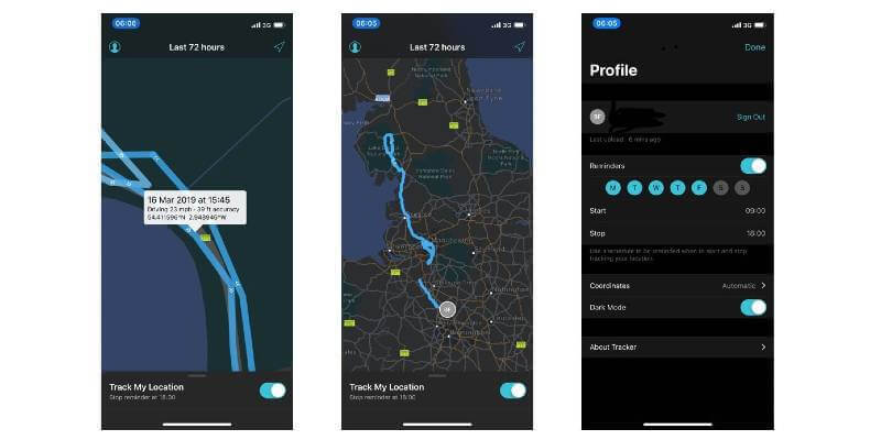
The study is using Esri UK’s smartphone ArcGIS Tracker app to examine changes in people’s movements at different stages of the pandemic. Results generated are informing government planning, Public Health and NHS responses to Covid-19, as lockdown eases and the countries prepare for a future of managing the pandemic.
The £3.2 million Government funded study, which began in June 2020 and runs until at least August 2021, is investigating the extent of the spread of coronavirus within communities and how factors such as social distancing affect the risk of infection. Run by UCL in conjunction with the NHS, UCL Virus Watch has over 50,000 members of the public taking part. The study uses online self-surveys about current health and symptoms, swabbing and antibody tests, plus the GPS movement data from over 1,400 volunteers via Esri’s mobile Tracker app. GPS data used for the mobility analysis was collected between September 2020 and May 2021 and has generated over 160 million location data points to date.
“Examining movement post-first vaccination is important as it helps policy makers understand how perceived protection from the vaccination programme may negatively offset the effectiveness of other policies, designed to reduce the spread of Covid-19,” explained Professor Robert Aldridge, Chief Investigator on the Virus Watch Study, UCL. “The study has been a major undertaking to create and become operational and is unique in the UK, due to how it links daily laboratory, vaccination, symptom and behavioural data with very rich GPS data. Our results require cautious interpretation but suggest that there was no significant increase or decrease in movement after a single vaccination."
“Other studies have suggested that people increase their number of non-household contacts after their first vaccination dose and so further research on people’s behaviour following vaccination is warranted. In the meantime, it is important that public health communications are clear about the differential protection against SARS-CoV-2 infection offered by the first and second doses of the vaccine, such that people can exercise sound personal judgement on how they alter behaviour change following vaccination."
“Whilst previous studies have attempted to investigate travel distances after vaccination, these were conducted using mobile call data, which is dependent on an individual making a call before a distance can be calculated. Our study demonstrates the feasibility of collecting high volume geolocation data as part of public health research projects. Not only does this improve accuracy of distance estimation, by using the GPS system (as compared to cellular location), it reduces recall biases when using self-reported data.”
Analysis of the location data is revealing how people react when they have the virus, symptoms, antibodies or have been vaccinated, showing different activity levels and modes of transport used, including vehicles, walking or running, for example. The 1,400 volunteers control the sharing of their location data via the app, which lets them either turn on or disable tracking in one click.
“Helping us to understand community incidence and transmission of Covid-19 in relation to population movement and behaviour, the findings are vital in informing government planning, Public Health and NHS responses to Covid-19,” continued Professor Aldridge. “When different tiers were introduced, we could see how far people travelled by car, and we’ve also been able to investigate the impact of vaccinations one day after a first jab on mobility. To understand Covid 19 properly, we need large community studies like Virus Watch that can follow-up people over time to see if they get ill and see what influences this. The more we understand the virus, the better equipped we will be to stop its spread, save lives and plan for the future.”
Esri’s ArcGIS Tracker app is a mobile solution which enables organisations to capture and analyse the tracks of people for various different industry applications. It forms part of the Esri UK solution being used by UCL Virus Watch Study, which also includes ArcGIS Online to store the data in the cloud and Esri’s other GIS tools to perform various types of analysis. The overall solution met the stringent data security requirements of UCL’s Information Governance team and also received approval from an NHS research ethics committee.
“The Esri UK tracking app was simple and easy for the public to understand and use, quick to deploy and very scalable in the cloud, while other Esri tools allow us to process and examine the large volumes of location data to reveal patterns of behaviour,” said Professor Aldridge.
“Location data offers an additional dimension to the UCL Virus Watch Study, providing insight into human behaviour that can inform government planning,” said Charles Kennelly, CTO at Esri UK. “Members of the public volunteer to provide their data and can easily manage when this occurs and for how long. This places control squarely in the hands of the individual, which is key to the success of healthcare projects such as this.”
The Esri software used for the UCL Virus Watch Study was donated by Esri UK's Covid-19 Disaster Response Programme, created to provide organisations with mapping and analytical capabilities for free, to help manage their response to the pandemic.
Esri UK and UCL are holding a webinar on Thursday 24th June at 11:00am–12:00pm, to discuss how real-time analysis can help make sense of IoT and location data, and explore new methods of tracking people and vehicles, as well as monitoring IoT networks in the cloud.

To hear more about the UCL Virus Watch Study, visit this link.
Subscribe to our newsletter
Stay updated on the latest technology, innovation product arrivals and exciting offers to your inbox.
Newsletter

