Share
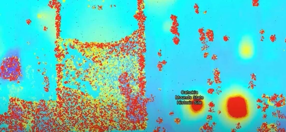
In a groundbreaking collaboration, RIEGL‘s advanced geospatial technology is playing a pivotal role in uncovering the mysteries of Cahokia Mounds, one of North America’s most significant archaeological sites.
The RIEGL miniVUX-3UAV system, a state-of-the-art airborne laser scanner, is at the forefront of this exploration, providing researchers with unprecedented precision and efficiency.
Designed for integration with UAVs, the RIEGL miniVUX-3UAV system offers a selectable laser pulse repetition rate of up to 300 kHz, delivering up to 100,000 measurements per second. This innovative technology allows for echo digitization and online waveform processing, enabling researchers to penetrate dense foliage and capture detailed data without disturbing the ground.
The collaboration between the National Geospatial-Intelligence Agency (NGA), Saint Louis University Research Institute (SLU), and the Taylor Geospatial Institute (TGI) is leveraging RIEGL‘s system to map and analyze the Cahokia Mounds with remarkable accuracy. The RIEGL miniVUX-3UAV’s compact design and robust aluminum housing make it ideal for various UAV platforms, ensuring flexibility and ease of use in the field. Watch the video below to get a quick overview of the project.
With a 360° field of view and multi-target resolution, the RIEGL miniVUX-3UAV is exceptionally well-suited for archaeological and cultural heritage documentation. Researchers are now able to reveal hidden structures and features that have remained undiscovered for centuries, offering new insights into the ancient civilization of Cahokia.
This project was important for NGA, SLU, and TGI because it leveraged modern geospatial technologies to uncover ancient secrets at Cahokia. This innovative approach not only enhances our understanding of Cahokia’s historical significance but also demonstrates the transformative power of modern geospatial technologies in uncovering the mysteries of the past. The collaboration showcased the power of geospatial intelligence in archaeological research, fostering innovation and advancing the capabilities of each organization. As RIEGL continues to push the boundaries of geospatial technology, the secrets of Cahokia Mounds are gradually coming to light, promising a deeper appreciation of this remarkable archaeological site.
Subscribe to our newsletter
Stay updated on the latest technology, innovation product arrivals and exciting offers to your inbox.
Newsletter