ENGIE to build 8 hybrid solar power plants in Gabon
6th August 2018
ENGIE to build 8 hybrid solar power plants in GabonNews as it happens! Keep in touch with the latest developments in business and technology in the regions or worldwide.
6th August 2018
ENGIE to build 8 hybrid solar power plants in Gabon6th August 2018
1Spatial adds Linear Reference System (LRS) support to 1Integrate6th August 2018
Dr. Teresa Thorpe Joins CSA Ocean Sciences as Proposal Coordinator6th August 2018
Hexagon acquires mine safety specialist, Guardvant4th August 2018
Linkfast to Provide Applanix Products and Solutions3rd August 2018
Airbus Defence and Space selected by Telesat3rd August 2018
Plowman Craven collaborates with Leica Geosystems on RTC3603rd August 2018
GSSI Announces New Technical Applications Specialist3rd August 2018
Malaysian Survey Consultants Jalal Johari Chooses SuperSurv as the Best Helper for Land Surveying2nd August 2018
OceanWise will be running a Marine Data Management Awareness Course2nd August 2018
Single Channel Pyroelectric Detector Housed in a 4 Pin Package2nd August 2018
Freemium plan for developers to build location-aware applications
1st August 2018
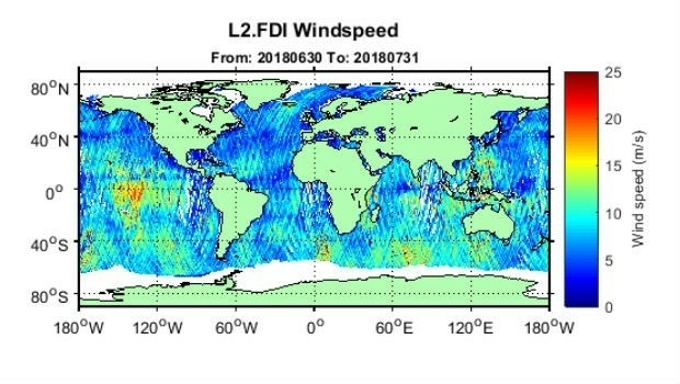
First global GNSS-Reflectometry ocean wind data service1st August 2018
UK New Space Launch capability to be discussed at Global MilSatCom 20181st August 2018
Bluesky Helps Malta Develop GeoSpatial Infrastructure31st July 2018
Skanska Speeds BIM Workflows with Pointfuse As-Built Models30th July 2018
OceanWise delivers accurate real-time weather data30th July 2018
Fugro’s David Millar To Serve On IHO-IOC GEBCO Guiding Committee27th July 2018
CGG announces the Appointment of Yuri Baidoukov as Group CFO
27th July 2018
3D PluraView Monitor Product Family expanded – new 22″ Full-HD Model27th July 2018
SuperGIS Desktop will further support MariaDB in the next update!