
Strategic agreements integrate Topcon technology into solutions from Bentley Systems and Worldsensing
15th April 2024
Strategic agreements integrate Topcon technology into solutions from Bentley Systems and WorldsensingNews as it happens! Keep in touch with the latest developments in business and technology in the regions or worldwide.
15th April 2024
Strategic agreements integrate Topcon technology into solutions from Bentley Systems and Worldsensing
12th April 2024
London Gatwick creates new geospatial platform with GIS from Esri UK
12th April 2024
Astroscale’s ADRAS-J Completes Successful Rendezvous and Initiates Proximity Approach11th April 2024
Septentrio mosaic GPS/GNSS now also available in MIKROE Click board ecosystem
11th April 2024
Sercel Announces First Commercial Sale of its New 528 Land Acquisition System10th April 2024
Creaform introduces the MetraSCAN BLACK+ and MetraSCAN BLACK+|Elite10th April 2024
u-blox incorporates newest Nordic Semiconductor Bluetooth chips in two new compact modules
9th April 2024
Meeting place for the global geospatial community – Stuttgart is being transformed into a stage for sustainable solutions and international cooperation9th April 2024
Space Flight Laboratory (SFL) Confirms Successful Deployment of HawkEye 360 Microsatellite Clusters 8 and 9
8th April 2024
Esri’s ArcGIS Basemaps Integrated into Autodesk Civil 3D and AutoCAD
8th April 2024
Teledyne FLIR IIS Announces a New Online Platform for Selecting Optimal Machine Vision Components for Imaging Systems
5th April 2024
Tomaž Petek elected President of EuroGeographics
5th April 2024
HawkEye 360 Secures $40 Million Debt Commitment
4th April 2024
TDI-Brooks Completes Large Survey Campaign Off New York And New Jersey
4th April 2024
Descartes Labs Accelerates Growth with Strategic Acquisition of Geosite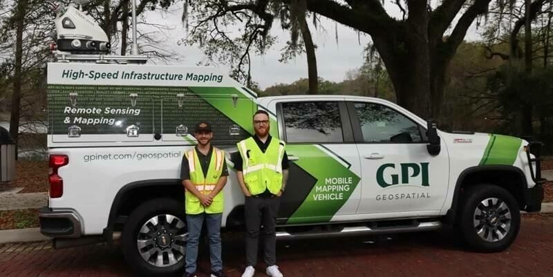
3rd April 2024
GPI Geospatial Enhancing Mobile Mapping with RIEGL LiDAR
3rd April 2024
Faroese Environment Agency joins EuroGeographics
2nd April 2024
Bilanciai Group and Topcon Announce Strategic European Collaboration
2nd April 2024
Coptrz Announces Launch of the “F00-1 LiPRA”: A Revolutionary Drone That Redefines the Impossible
1st April 2024
Esri Releases New Book Designed to Improve Efficiency of Mobile Work1st April 2024
Kongsberg Satellite Services has acquired majority stake in Norwegian startup VAKE29th March 2024
Spire Global Announces Space Services Deal to Scale Constellation for HANCOM InSpace
29th March 2024
Esri and the District of Columbia Partner to Launch DC’s AI-Powered ‘Compass’
28th March 2024
Parksafe Group Teams Up With Queclink Wireless Solutions In Fleet Technology Partnership