
NAV CANADA signs strategic agreement with Terra Drone’s portfolio company Unifly
2nd March 2020
NAV CANADA signs strategic agreement with Terra Drone’s portfolio company UniflyNews as it happens! Keep in touch with the latest developments in business and technology in the regions or worldwide.
2nd March 2020
NAV CANADA signs strategic agreement with Terra Drone’s portfolio company Unifly28th February 2020
The 4th Next Generation Cyber Security for Utilities Conference
27th February 2020
HERE unveils Geodata Models to lower 5G wireless network planning costs27th February 2020
New environmental monitoring systems at two key Ghana ports
27th February 2020
NAV CANADA signs strategic agreement with Unifly
27th February 2020
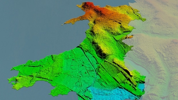
Bluesky Awarded LiDAR Contract to Map Wales from the Air26th February 2020
BOEM and CSA Release Atlas of US Waters Submarine Canyons

26th February 2020
New Camera to make Crop Disease Detection Easier and Less Expensive
26th February 2020
ABPmer delivers PMSC audit for Cowes Harbour Commission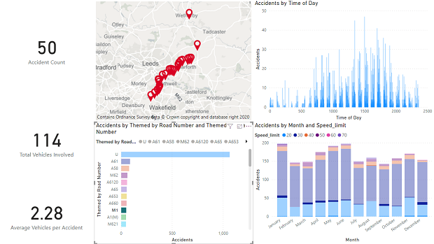
25th February 2020
New Power BI custom visual for embedding interactive maps25th February 2020
Pléiades Neo well on track for launch mid-2020
25th February 2020
Casablanca’s Medina Buildings Monitored During Tunnel Construction
24th February 2020
4 Earth Intelligence Appoints Board to Drive Innovation in Satellite Services
24th February 2020
1Spatial forms strategic partnership with Neueda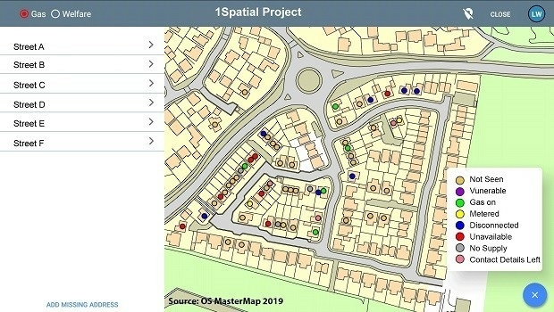
24th February 2020
1Spatial announce new mobile platform for spatial data collection23rd February 2020
Envitia appoints new Chief Technology Officer to Board of Directors
23rd February 2020
OGC Invites Developers to its Environmental Data Retrieval API Sprint
23rd February 2020
RIEGL will be Attending and Exhibiting at CHC 2020
23rd February 2020
GSSI to Showcase GPR systems at ConExpo-Con/Agg Show
21st February 2020
Paracosm Partners with Geo-Plus to Expand Land Survey Offerings