Share
MONTREAL, CANADA — Eos Positioning Systems, Inc.® (Eos) announced today its support for GEOID height models within its Arrow Series™ GNSS receivers. Eos is the world’s leading manufacturer of affordable high-accuracy GNSS receivers for any app running on iOS/Android/Windows devices and using the Eos Arrow Series.
“You can use Arrow Series receivers with any data collection software in the world, and benefit from accurate orthometric heights,” Eos CTO Jean-Yves Lauture said. “Our Arrow receivers will output accurate GNSS elevations no matter which data-collection software you use to capture it.”
Compatibility and Availability
With support for GEOID models, Arrow receivers automatically output survey-grade elevations to all iOS and Android data collection software. Support will also soon be available for Windows devices.
The Arrow receivers now support the entire United States to provide survey-grade elevation in NAVD88 orthometric heights through the GEOID12B (US) model. The Arrow receivers also support the Canadian CGG2013a and HTv2.0 GEOID models for the CGVD2013 and CGVD28 vertical datums, respectively. Additional GEOID models for other countries are planned in the future.
“Eos is intensely focused on supporting high-accuracy GIS, engineering, surveying and construction users by supporting the latest GEOID elevation models within our GNSS monitoring software,” Lauture said. “Our roadmap remains focused on high-accuracy BYOD users by supporting all iOS, Android and Windows users with this capability.”
Need and Use Cases
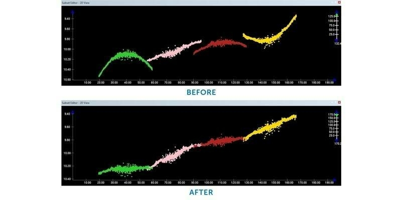
The problem is that typical Bluetooth GNSS receivers usually provide inaccurate, built-in elevation models. This inaccuracy is reflected in the Mean Sea Level (MSL) elevation output by those receivers. By outputting orthometric height, the Arrow now solves this problem and turns any smartphone or tablet into a 3D, survey-grade accurate data collection device.
Eos has designed this new feature so that users will easily be able to update to new GEOID models as they become available in the future.
Field technicians in pipeline, construction, engineering, architecture, water, and any other industry are finally able to enjoy GNSS location with survey-grade vertical accuracy on their iOS and Android devices, with the data-collection app of their choice and their Eos Arrow receivers.
“We are pleased to offer this important feature to all mobile GIS software users,” Lauture said.
Subscribe to our newsletter
Stay updated on the latest technology, innovation product arrivals and exciting offers to your inbox.
Newsletter