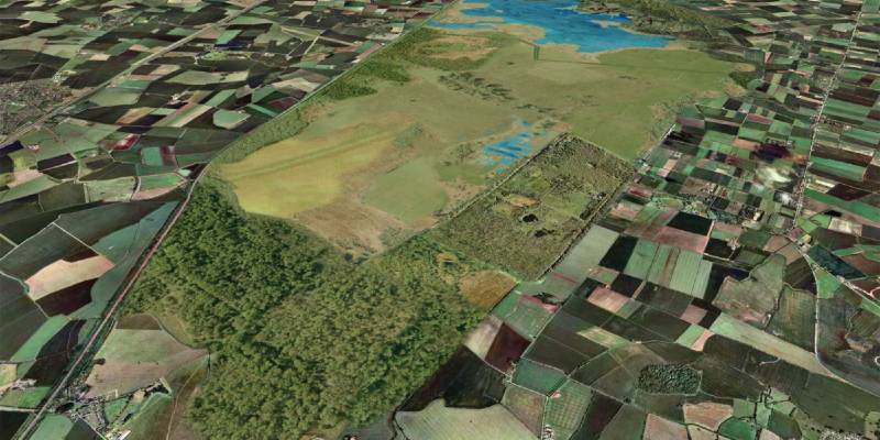
Aerial photography from Bluesky is being used to help promote investment in nature in order to reduce climate change.
Featured in a recently published report by The Wildlife Trusts ‘Let nature help – how nature’s recovery is essential for tackling climate change’, the Bluesky imagery was used to create a landscape architect vision of the Great Fen project in Cambridgeshire. One of the largest restoration projects of its kind in Europe, the Great Fen project aims to restore 3,700 hectares of wetland habitat.
Originally used by the Bedfordshire, Cambridgeshire and Northamptonshire (BCN) Wildlife Trust, the Bluesky aerial photography combines the current real world view of the Great Fen – a vast fenland landscape located between Peterborough and Huntingdon, with the Trust’s vision of how the site could look in 2030.
“With such a large-scale, long term project it is important that we can communicate both the extent and detail of the project,” commented Jo Richards, Head of Communications at The Wildlife Trusts. “The Bluesky imagery helps us to do this placing our vision of the 18 square miles of restored wetland in the context of the existing nature reserves and surrounding farmland and local communities.”
Managed in partnership by the Environment Agency, Natural England, local authorities and land managers it is hoped that the Great Fen project will reconnect the existing Holme Fen and Woodwalton Fen National Nature Reserves to create a huge mosaic of wetland habitats. Benefiting people and wildlife this will also reduce the risk of flooding on nearby farmland and save an estimated 325,000 tonnes of CO2 from being produced each year through peat loss.
In a parallel move the Water Works project is aiming to change the face of farming in the Cambridgeshire fens. Working with partners and local farmers the Wildlife Trust BCN is trialling innovative wetland farming techniques that will help rewet the fen and halt the release of carbon.
A specialist in aerial surveys Bluesky is the first, and only, commercial organisation to successfully capture and maintain complete aerial photographic coverage of England, Scotland and Wales as well as the Republic of Ireland. Bluesky also recently announced new plans to photomap the whole of Great Britain at 12.5 centimetre resolution – its highest level of detail for nationwide coverage to date.

Subscribe to our newsletter
Stay updated on the latest technology, innovation product arrivals and exciting offers to your inbox.
Newsletter

