Share
Matt White discussed the importance of high-quality asset data within our national infrastructure and the stages in the lifecycle of an asset.
This week, the focus is on the location of the asset and the need for a high-quality geospatial data infrastructure.
Sustainable information management framework
Having a robust and sustainable information management framework is often sighted as a key foundation for an infrastructure asset lifecycle and is becoming even more important as organisations digitalise the asset lifecycle and aspire to develop digital twins. An information management framework sits around the infrastructure asset lifecycle. The CDBB has set out a roadmap for an information management framework.
Everything happens somewhere
“Everything happens somewhere” and this is so true for our national infrastructure. All our infrastructure, for example flood risk management has a location. Geospatial/location is therefore a primary data source for an infrastructure asset lifecycle information management framework.
The role of geospatial:
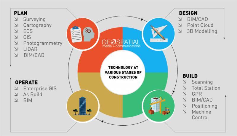
Geospatial/location touches every stage of the infrastructure asset lifecycle and therefore geospatial needs to be part of the infrastructure asset lifecycle information management framework.
Geospatial data infrastructures and DataOps
I have previously written about the evolution of geospatial data infrastructures and growth of DataOps. DataOps is an automated and process led approach used by data teams to improve the use of data as information through better data quality, shorter cycle times and effective data management. DataOps applies to the entire data lifecycle from data preparation to reporting. DataOps promotes collaboration, orchestration, quality, security, access and ease of use.
DataOps approaches will be critical to evolving geospatial data infrastructures, underpinning information management frameworks for digital infrastructure asset lifecycles and in the future digital twins.
1Spatial’s approach to evolving geospatial data infrastructures
1Spatial’s approach to evolving geospatial data infrastructures for digital infrastructure asset lifecycle follows learning by ‘doing’, overcoming by ‘sharing’ and succeeding ‘together’ through data Collaboration, data Automation, data Transformation, data Validation and data Visualisation principles for data (geospatial) infrastructures.
Data Collaboration – working with employees and stakeholders internally and externally to share asset data management and asset data governance responsibilities
Data Automation – designing and implementing automated workflows to manage, govern and share asset data
Data Transformation – making asset data fit for purpose by transferring data between data source(s) and target interface(s)
Data Validation – making asset data fit for purpose by meeting data specifications/standards
Data Visualisation – making asset data accessible for people and decision-makers to use
Making infrastructure asset data easier to work with
The above data collaboration, data automation, data transformation, data validation and data visualisation principles enable organisations to evolve geospatial data infrastructures, an integral part to an information management framework for digitalising the infrastructure asset lifecycle. 1Spatial makes infrastructure asset data easier not harder to work with, by working with people who work with asset data, applying processes and technology for example; 1Data Gateway, 1Integrate, FME and Geocortex.
1Spatial’s solutions for geospatial data infrastructures can make asset data easier not harder to work with by data collaboration, data automation, data transformation and data visualisation capabilities across your infrastructure asset lifecycle and future digital twins.
Are you transforming the way you plan, design, build and operate national infrastructure using geospatial data infrastructures?
Get in touch, if you would like to discuss this further with our team
Author Matthew White, 1Spatial
Subscribe to our newsletter
Stay updated on the latest technology, innovation product arrivals and exciting offers to your inbox.
Newsletter

