Share
More than 7,000 ambulances across Britain are set to benefit from a new life-saving navigation system that will speed response times and improve patient care. Kate Patfield reports on how the in-cab system is underpinned by data from Ordnance Survey, the nation’s leading mapping organisation

The system is being delivered by the Ambulance Radio Programme (ARP), an initiative established in 2007 by the Association of Ambulance Chief Executives (AACE), and funded by the Department of Health and Social Care (DHSC). Its purpose is to deliver critical technological system improvements, providing enhanced Voice and Data communications between Ambulance Trusts, the NHS and other emergency responders
As part of the programme, it was recognised that the existing navigation systems needed a technical refresh, taking into account factors such as the age of equipment, contract lengths and improvements in technology in the sector.
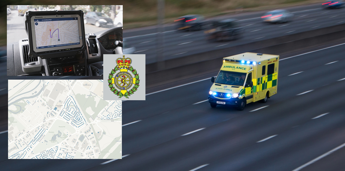
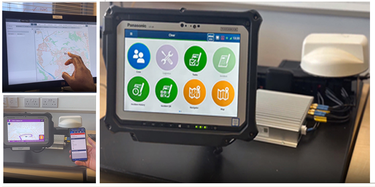
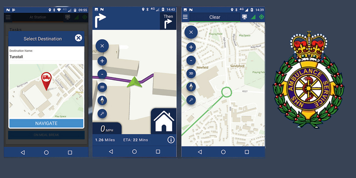
Last year, the ARP began the rollout of the Mobile Data and Vehicle Solution (MDVS) Programme, which replaces communication equipment with a new system that includes a Windows 10 LTSC operating system with a National Mobilisation Application (NMA) on a tablet mounted to the vehicle dashboard. This enables the deployment of the NMA to all English and Welsh Ambulance NHS Trust front-line emergency vehicles.
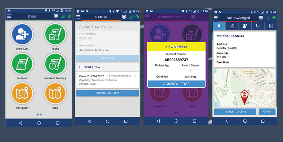
The NMA uses voice acknowledgement to enable interaction with the device whilst mobile, conforming with the Road Traffic Act. The application is used to dispatch ambulance resources to incidents and operates on the replacement vehicle and handheld equipment. This hardware consists of a tablet mounted into the vehicle with associated brackets and a vehicle router providing connectivity.
DHSC, via its Public Sector Geospatial Agreement (PSGA) licence, contracted Terrafix to build the application on behalf of ambulance services. The NMA was then developed with the support of Ambulance Trusts in England and Wales.
Nationwide consistency
Crucially, the PSGA licence enabled Terrafix to integrate OS addressing, roads and mapping products such as OS Zoomstack, OS MasterMap Highways Network and AddressBase Plus into the NMA, therefore bringing navigation in line with the same OS datasets in every NHS computer aided dispatch system used in emergency control rooms across the country.
The new system sends incident information to the crews, underpinned by enhancements such as voice activation, improved satellite navigation and the latest detailed mapping of Britain’s rural and urban areas, all of which support ambulance crews getting to the scene of a patient as quickly as possible.
Not only does this mean that all NHS services will be accessing and using the same and most authoritative addressing and mapping data in the country, but ambulances no longer need to be taken off the road to download the latest mapping and navigation data. The new service no longer requires manual data uploads as mapping updates can now be regularly streamed to the in-cab system using designated Wifi and over-the-air technology at key operational sites, minimising disruption to Trust operations.
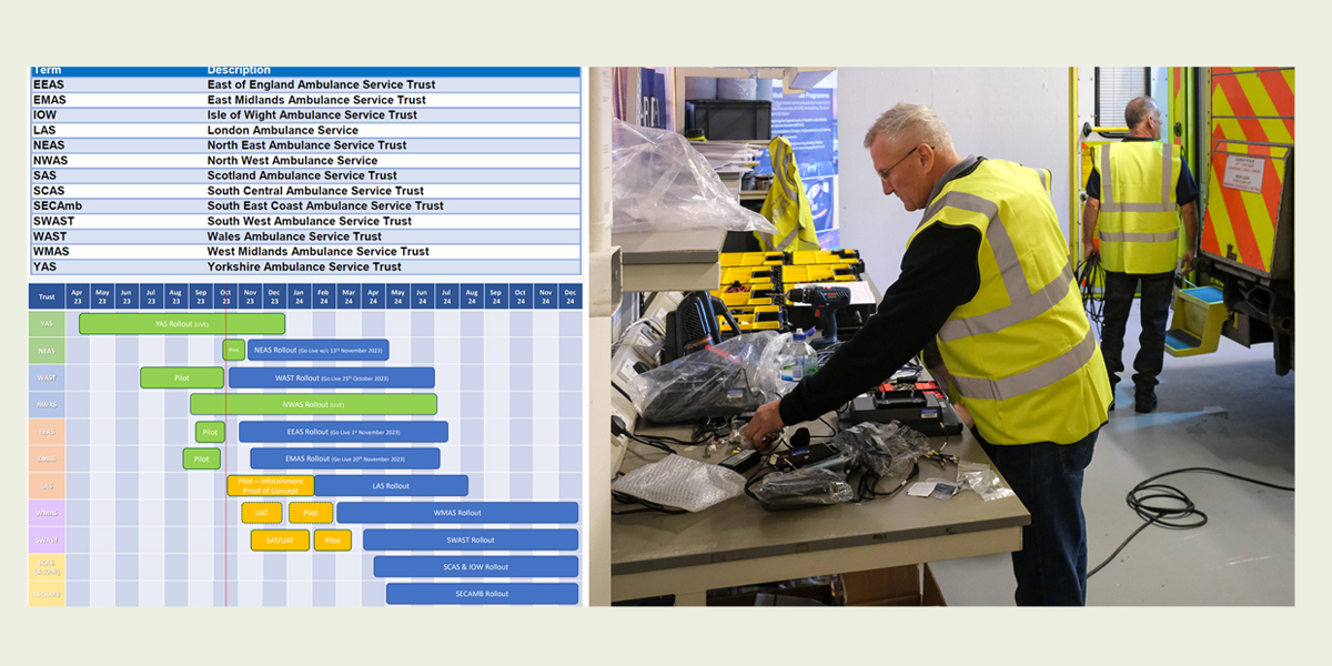
Yorkshire pilot
Yorkshire Ambulance Service (YAS) NHS Trust was the first Trust to run a pilot to install the NMA and then go live with the roll-out across its fleet of over 650 ambulances and rapid response vehicles back in April 2023. YAS have since completed a rollout of over 650 vehicles within their main fleet, contributing to a running, live total of over 3,500 vehicles installed nationally across a further 9 Ambulance Trusts. South East Coast & the Isle of Wight Ambulance Services are the final Ambulance Trusts to go live with the MDVS this calendar year.
Simon Marsh, chief information officer at YAS NHS Trust and project sponsor said: “YAS is proud to be the first to implement the new solution into our ambulance and rapid response vehicle fleet. Having access to accurate and up-to-date mapping is essential to all the emergency services, and with ambulances it can make all the difference to our patient care and response times through improved navigation.
“Ordnance Survey mapping is a key feature of the new solution. We now have up-to-date, accurate mapping data being streamed to the vehicles, ensuring that we are always navigating and working with the best and most trusted information. It also means that vehicles no longer have to be taken off the road to download the latest maps and data.”
Excellent collaboration
ARP Director Duncan Bray has been overseeing the national programme, which involves the ten Ambulance Trusts in England, plus Wales and the Isle of Wight. He has been delighted by the excellent collaboration he has seen, from technology services to data providers.
There are now vehicles using the NMA in Yorkshire, North West, Wales, North East, East of England, East Midlands, South West, West Midlands, South Central, & London Ambulance Trusts – the latter being the largest with a fleet of approximately 1,000 ambulances. During 2024 the products will be live in every Ambulance Trust in England and Wales.
Duncan recognises that the roll-out is not without its challenges. Fitting the NMA in multiple locations within a Trust, providing training to busy crews, as well as releasing ambulances from frontline duties without impacting on operations is a constant balance and challenge. But he was also confident that any difficulties would be overcome. Every Trust has its own pilot, therefore making sure the new system meets the needs of each region before it is rolled out more fully across its entire fleet.
He said: “Ultimately, we want to have a national solution that supports all ambulance services to respond to emergencies in a quick, safe and efficient way. Accurate mapping is crucial, and providing access to the latest data will deliver huge benefits to everyone. The feedback from the ambulance crews on the new system to date has been outstanding. We have frontline operational crews benefitting from having a national application, with voice activation, new hardware and software, all underpinned by improved satellite navigation and mapping technologies. Giving operational colleagues the latest technology to support them in providing the very best patient care is something we are immensely proud of in the Ambulance Radio Programme.”
Cutting-edge solution
Terrafix, which is a supplier of ICT and Mobile Data Systems to the police and other emergency-based organisations, as well as the UK Ambulance Service, was keen to work with OS on the ARP. Its Managing Director, Chris Green, said: “Terrafix is extremely proud to have been awarded both the National Mobilisation Software and National Vehicle Hardware contracts by the DHSC. Together, both contracts provide a completely new, cutting-edge solution for all Ambulance Trusts.
“After researching all possible mapping products, it was clear that the OS Mapping was by far the best choice to use. The mapping underpins the NMA's functionality. With accurate data and regular updates, the feature-rich mapping facility will provide ambulance crews with the best possible methods of routing and navigation.
“As Terrafix is also heavily involved in providing the Field Services contract to support the Ambulance Trusts throughout the product lifecycle, it is vital that to deliver the optimum performance, the software and primarily the mapping remain completely accurate and up-to-date giving the frontline workforce the best user experience possible.”
OS has a long history of supporting the emergency services with authoritative location data. The PSGA provides access to OS data for all the emergency services and has become essential in daily operations across the police, fire, ambulance and coastguard services.
John Kimmance, Managing Director of National Mapping Services at OS, said: “Today, accurate and trusted OS data is being used every day to support a range of critical services from enabling quicker responses to incidents to planning and delivering safe and secure major events.
“Every week we make tens of thousands of changes to the National Geographic Database capturing new buildings, roads, routing restrictions and addresses. This is essential data for all emergency responders, and it is great that the new NMA is delivering this data direct to the vehicles ensuring they are working with the same mapping as the 999 control rooms.”
• PSGA membership gives the public sector access to OS expertise and location data for free. For more information, please visit: The PSGA | Government and public sector | OS (ordnancesurvey.co.uk)
• For more information the ARP, please visit https://ambulanceradioprogramm...
Kate Patfield is Senior Press Officer with Ordnance Survey in Southampton, Hampshire (https://www.ordnancesurvey.co....)
Subscribe to our newsletter
Stay updated on the latest technology, innovation product arrivals and exciting offers to your inbox.
Newsletter