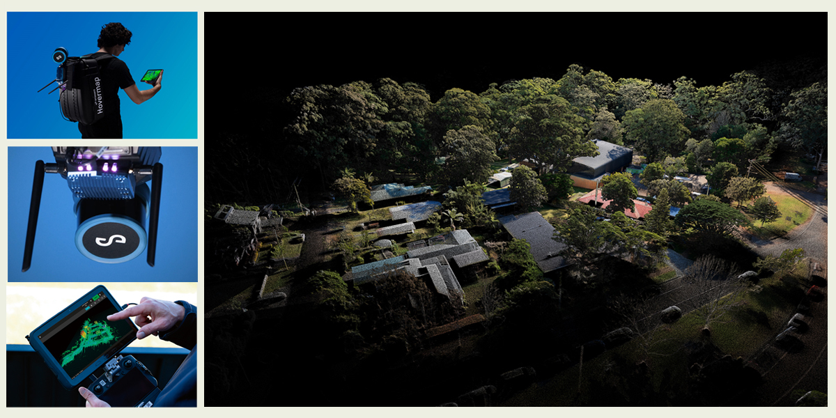
Having cut its teeth on making Australia’s underground mining industry a safer place to work, Emesent is bringing its innovative LiDAR solutions to a global audience. GeoConnexion caught up with its co-founder and Chief Strategy Office, Dr Stefan Hrabar (pictured below), to find out more

GeoConnexion (GEO): Can you outline how Emesent has evolved since its 2018 spin-off from Australia’s CSIRO Robotics and Autonomous Systems Group, e.g., its global reach; its growth in headcount, and the range of skills and expertise it deploys?
Dr Stefan Hrabar (SH): Last year we celebrated our fifth year in business. Since launching Emesent and our original product, Hovermap, with just a handful of employees based in Brisbane Australia, we’ve now grown into a company of over 120 people spanning multiple locations both in Australia, Europe and the US. The Emesent team covers a diverse set of skills, expertise and experience which includes research, engineering, manufacturing, user experience, sales, marketing, channel management, technical support, administration, finance, and HR, among others.
But beyond that we’ve been building a global network of over 45 reseller partners. We are focused on building this community over the next few years to help with both geographic and sector-specific expansion.
GEO: How has Hovermap evolved to embrace new applications?
SH: Since its original application in the mining industry, we’ve seen a growing need for safely capturing accurate data in other industries – like oil and gas, AEC and even public safety – that too often involve dangerous, time-sensitive, or inaccessible environments. As a result, we’ve adapted Hovermap to support a range of other use cases. We’ve also added new capabilities such as colorisation, GPS integration, GCP, and others – to drive greater accuracy and also make data interpretation even easier.
At the same time, we’ve ensured Hovermap remains as versatile as possible by creating a range of accessories for handheld and vehicle use. We continue to support multiple drone platforms. And more recently, we’ve developed complementary capabilities for platforms like the Boston Dynamics Spot agile robot – for environments where drones can’t go. Looking forward, we’ll continue to expand the ways in which Hovermap can be deployed.
GEO: Early adopters of Hovermap were customers in Australia, Canada, China and Japan. Has this since been extended to other countries? And where do you see the biggest market(s) going forward?
SH: We’ve seen a natural growth path in countries where mining represents a key driver of economic growth. The value proposition for Hovermap has remained the same: fast, accurate, and safe capture of actionable data in dangerous and inaccessible environments. In keeping with that, our partnerships have extended to countries across Africa, central Asia and South America. What we are also seeing is growing interest from markets outside of underground mining, such as Europe, the Middle East and Asia, which tend to see a value in applying Hovermap to scenarios in built environments and asset monitoring.
GEO: INTERGEO 2022 in Essen saw Emesent launch Hovermap ST-X with improved LiDAR sensor accuracy, a Long Range Radio add-on, and the Aura software platform that integrates SLAM processing and point cloud visualisation. What was the market reaction and uptake to these newcomers?
SH: People are typically impressed by the quality, speed, accuracy and distance that Hovermap ST-X can achieve, especially in inaccessible and GPS-denied environments. Meanwhile, Long Range Radio, which is a Hovermap add-on, is designed to extend mission range and reach – and we have a specific group of clients that really need that capability.
When we launched Aura, it was literally the beginning of this product. At this year’s INTERGEO in Berlin we released a significant update in functionality – and clients who have already started using it are extremely enthused by the way it automates point cloud cleaning. We couldn’t be happier.
GEO: At launch, it was said that the Aura platform laid the foundation for future point cloud analytics modules that Emesent was developing. Can you update us on this development?
SH: As the developers of Hovermap, the data capture side of the equation has always been important to us, but so too is the data processing and analysis side. That’s where Aura comes into play. At this year’s INTERGEO in Berlin we showcased new capabilities that offer practical support in data processing and visualisation, including features such as automated point cloud cleaning and true-to-life colorisation.
This builds on existing capabilities such as our Automated Ground Control feature which leverages GCP targets and uses these to both georeference the point cloud and improve the accuracy of the SLAM result.
While we have just released Aura 1.2 -- the product is only just getting started – we have a longer-term vision for how this software will evolve to provide better insight into the data that’s been captured by Hovermap. We’ll continue to add new usability and data-handling capabilities over time – in fact there will be a few things to watch out for early in 2024 so stay tuned.
GEO: Hovermap Core was unveiled, at last year’s INTERGEO Expo in Berlin. Can you explain how it fits into the Hovermap portfolio and its advantage over other handheld scanning solutions?
SH: Many AEC clients have been calling out for a version of Hovermap that better suits their own working model, which tends to be project-based. From a use-case perspective this means a focus on mapping over autonomous data capture via drone or robot.
With this in mind, Hovermap Core offers a business solution aligned to the way companies working in the AEC space operate. That said, we have not downgraded the quality of our data capture, processing or visualisation – users will still benefit from the same high standard.
GEO: AI and Machine Learning are areas in which Emesent is pursuing new possibilities. Can you give an idea of how these technologies are being incorporated in your solutions?
SH: There is a lot of hype around AI and ML. Up until now, Emesent has taken what we’d consider a more traditional approach in the implementation of our autonomy capabilities, which doesn’t rely on AI or ML. It is true that we are looking at how these technologies can be incorporated into our data analytics software – but a commercial implementation has not yet been released. That said, Emesent already uses ML during our payload calibration process which helps us produce superior maps. And given our strong focus on R&D, we’ll continue to look at how these technologies can be leveraged to improve our data capture and analysis.
GEO: What do you see as the main drivers to the company’s future growth?
SH: There are some major trends that will drive future growth. In fact, both are already energizing the adoption of 3D data capture and enterprise autonomy. Broadly speaking, the first is digitisation of workflows and the incorporation of data insights into the way businesses make and then act on decisions. Having the ability to capture, process and then visualise that data becomes a game changer for organisations that operate in high-risk environments and where the lack of accurate real-time information may delay an operational response.
The second major trend is specific to mining but will help radically transform the global economy. That’s the mining of critical minerals, which is being driven by global energy transition and carbon reduction goals. We’re already seeing this trend accelerate in Australia and other resource-rich economies. Emesent will play its part in supporting businesses looking to minimize their carbon footprint while maximizing productivity through fast and accurate – and importantly, safe – data collection and analysis. This transition is driving prioritization of ESG objectives and even the makeup of the workforce. There are opportunities here for organizations to re-skill and upskill, with a stronger emphasis on digital literacy and data fluency – something that most people may not immediately associate with the mining industry.
GEO: And what do you consider are the biggest challenges going forward?
SH: At a company level — and maybe also at a personal level — one of the biggest challenges will be to maintain our focus. We’re challenged every day to solve problems across multiple industries and in what seems to be an ever-expanding range of scenarios. So, it will be important to continue innovating while not being distracted from doing the things we do best.
The other challenge concerns the environments we all inhabit, now and in the future. Our vision is to continue mapping the inaccessible — whether it be underground, a built or natural landscape, or even spaces that have yet to be discovered. And in many ways, we don’t know what challenges these environments might pose. But I like to look at this not so much as a challenge, but more as an opportunity in which both me and the entire Emesent team can excel.

Subscribe to our newsletter
Stay updated on the latest technology, innovation product arrivals and exciting offers to your inbox.
Newsletter

